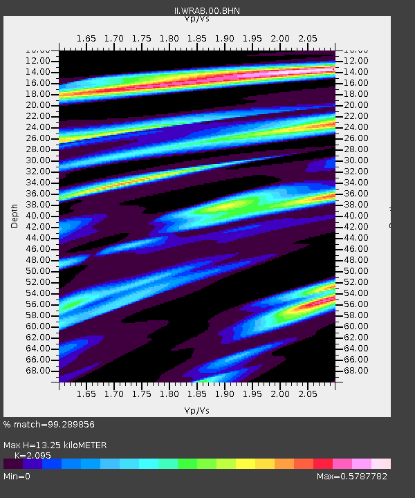
WRAB Tennant Creek, NT, Australia - Earthquake Result Viewer
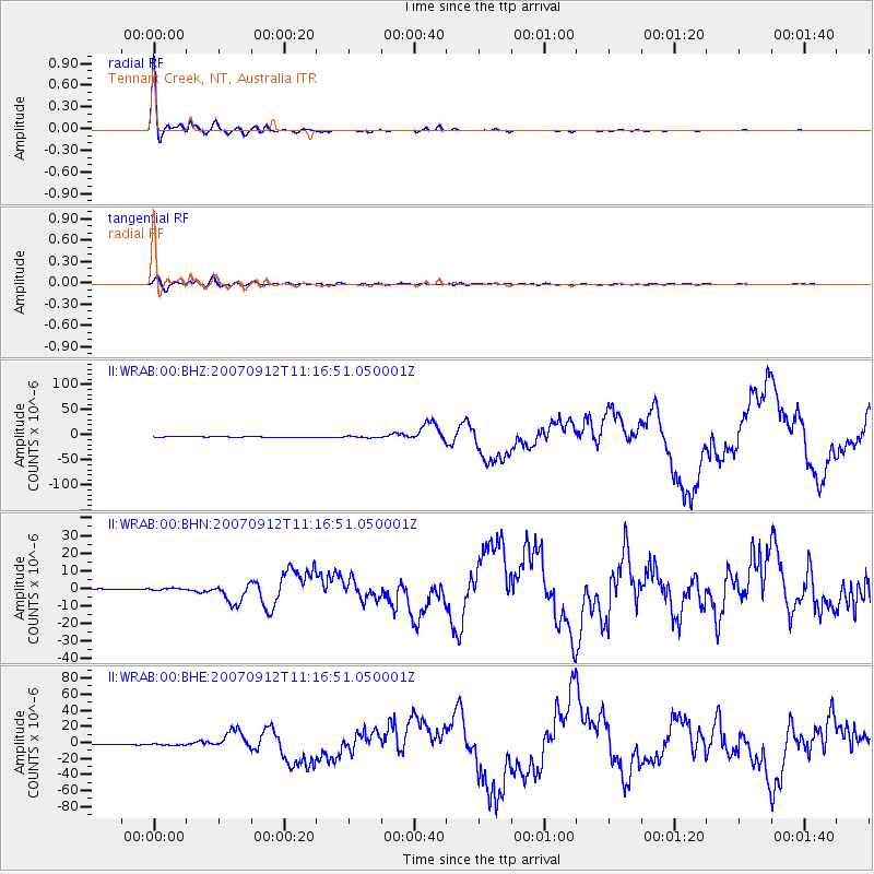
Earthquake location: Southern Sumatra, Indonesia
Earthquake latitude/longitude: -4.4/101.4
Earthquake time(UTC): 2007/09/12 (255) 11:10:26 GMT
Earthquake Depth: 34 km
Earthquake Magnitude: 6.9 MB, 8.5 MS, 8.4 MW, 8.0 ME
Earthquake Catalog/Contributor: WHDF/NEIC
Network: II Global Seismograph Network (GSN - IRIS/IDA)
Station: WRAB Tennant Creek, NT, Australia
Lat/Lon: 19.93 S/134.36 E
Elevation: 366 m
Distance: 35.6 deg
Az: 118.422 deg
Baz: 291.247 deg
Ray Param: 0.077056974
Estimated Moho Depth: 13.25 km
Estimated Crust Vp/Vs: 2.10
Assumed Crust Vp: 6.642 km/s
Estimated Crust Vs: 3.17 km/s
Estimated Crust Poisson's Ratio: 0.35
Radial Match: 99.289856 %
Radial Bump: 236
Transverse Match: 88.59939 %
Transverse Bump: 400
SOD ConfigId: 2564
Insert Time: 2010-03-01 23:19:33.158 +0000
GWidth: 2.5
Max Bumps: 400
Tol: 0.001

Signal To Noise

ChannelStoNSTALTA
II:WRAB:00:BHN:20070912T11:16:51.050001Z3.0962326.469693E-72.0895375E-7
II:WRAB:00:BHE:20070912T11:16:51.050001Z3.1761089.3334853E-72.938655E-7
II:WRAB:00:BHZ:20070912T11:16:51.050001Z4.4002471.3879139E-63.1541728E-7
Arrivals
Ps2.3 SECOND
PpPs5.8 SECOND
PsPs/PpSs8.1 SECOND