You are here: Home > Network List > II - Global Seismograph Network (GSN - IRIS/IDA) Stations List
> Station KAPI Kappang, Sulawesi, Indonesia > Earthquake Result Viewer
KAPI Kappang, Sulawesi, Indonesia - Earthquake Result Viewer
| Earthquake location: |
Kermadec Islands, New Zealand |
| Earthquake latitude/longitude: |
-30.1/-177.7 |
| Earthquake time(UTC): |
2014/06/23 (174) 19:19:16 GMT |
| Earthquake Depth: |
20 km |
| Earthquake Magnitude: |
6.9 MWW, 6.7 MWB, 7.2 MI |
| Earthquake Catalog/Contributor: |
NEIC PDE/NEIC COMCAT |
|
| Network: |
II Global Seismograph Network (GSN - IRIS/IDA) |
| Station: |
KAPI Kappang, Sulawesi, Indonesia |
| Lat/Lon: |
5.01 S/119.75 E |
| Elevation: |
300 m |
|
| Distance: |
63.8 deg |
| Az: |
279.869 deg |
| Baz: |
121.034 deg |
| Ray Param: |
0.059292167 |
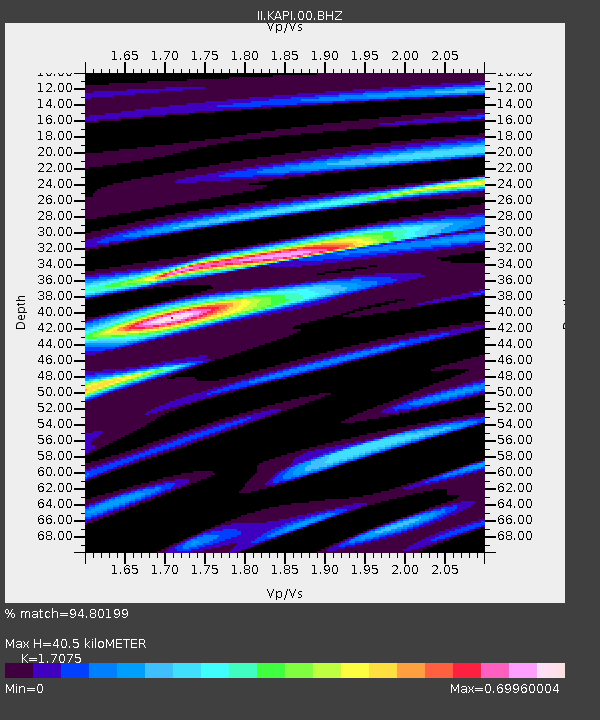
| Estimated Moho Depth: |
40.5 km |
| Estimated Crust Vp/Vs: |
1.71 |
| Assumed Crust Vp: |
6.343 km/s |
| Estimated Crust Vs: |
3.715 km/s |
| Estimated Crust Poisson's Ratio: |
0.24 |
|
| Radial Match: |
94.80199 % |
| Radial Bump: |
387 |
| Transverse Match: |
91.20282 % |
| Transverse Bump: |
400 |
| SOD ConfigId: |
739768 |
| Insert Time: |
2014-07-07 19:55:49.399 +0000 |
| GWidth: |
2.5 |
| Max Bumps: |
400 |
| Tol: |
0.001 |
|

Signal To Noise
| Channel | StoN | STA | LTA |
| II:KAPI:00:BHZ:20140623T19:29:16.318999Z | 15.742462 | 1.7856523E-6 | 1.1342903E-7 |
| II:KAPI:00:BH1:20140623T19:29:16.318999Z | 2.9093153 | 3.7414736E-7 | 1.2860323E-7 |
| II:KAPI:00:BH2:20140623T19:29:16.318999Z | 8.93998 | 8.699066E-7 | 9.730521E-8 |
| Arrivals |
| Ps | 4.7 SECOND |
| PpPs | 17 SECOND |
| PsPs/PpSs | 21 SECOND |


