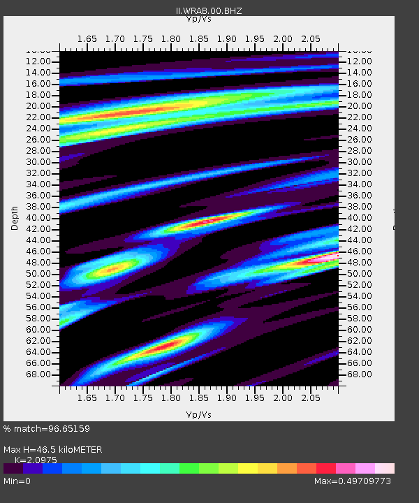
WRAB Tennant Creek, NT, Australia - Earthquake Result Viewer
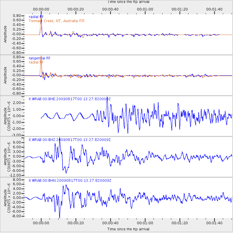
Earthquake location: Southwestern Ryukyu Isl., Japan
Earthquake latitude/longitude: 23.5/123.5
Earthquake time(UTC): 2009/08/17 (229) 00:05:49 GMT
Earthquake Depth: 20 km
Earthquake Magnitude: 6.2 MB, 6.6 MS, 6.7 MW, 6.6 MW
Earthquake Catalog/Contributor: WHDF/NEIC
Network: II Global Seismograph Network (GSN - IRIS/IDA)
Station: WRAB Tennant Creek, NT, Australia
Lat/Lon: 19.93 S/134.36 E
Elevation: 366 m
Distance: 44.5 deg
Az: 165.337 deg
Baz: 345.699 deg
Ray Param: 0.071882635
Estimated Moho Depth: 46.5 km
Estimated Crust Vp/Vs: 2.10
Assumed Crust Vp: 6.642 km/s
Estimated Crust Vs: 3.167 km/s
Estimated Crust Poisson's Ratio: 0.35
Radial Match: 96.65159 %
Radial Bump: 308
Transverse Match: 80.4867 %
Transverse Bump: 400
SOD ConfigId: 2622
Insert Time: 2010-03-01 23:19:50.228 +0000
GWidth: 2.5
Max Bumps: 400
Tol: 0.001

Signal To Noise

ChannelStoNSTALTA
II:WRAB:00:BHZ:20090817T00:13:27.820009Z5.12639331.8749272E-63.6574002E-7
II:WRAB:00:BHN:20090817T00:13:27.820009Z3.61376058.732799E-72.4165408E-7
II:WRAB:00:BHE:20090817T00:13:27.820009Z1.52129894.7950647E-73.1519542E-7
Arrivals
Ps8.1 SECOND
PpPs20 SECOND
PsPs/PpSs29 SECOND