You are here: Home > Network List > IU - Global Seismograph Network (GSN - IRIS/USGS) Stations List
> Station MBWA Marble Bar, Western Australia > Earthquake Result Viewer
MBWA Marble Bar, Western Australia - Earthquake Result Viewer
| Earthquake location: |
Kermadec Islands, New Zealand |
| Earthquake latitude/longitude: |
-30.1/-177.7 |
| Earthquake time(UTC): |
2014/06/23 (174) 19:19:16 GMT |
| Earthquake Depth: |
20 km |
| Earthquake Magnitude: |
6.9 MWW, 6.7 MWB, 7.2 MI |
| Earthquake Catalog/Contributor: |
NEIC PDE/NEIC COMCAT |
|
| Network: |
IU Global Seismograph Network (GSN - IRIS/USGS) |
| Station: |
MBWA Marble Bar, Western Australia |
| Lat/Lon: |
21.16 S/119.73 E |
| Elevation: |
190 m |
|
| Distance: |
56.5 deg |
| Az: |
263.36 deg |
| Baz: |
112.772 deg |
| Ray Param: |
0.0640522 |
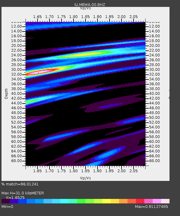
| Estimated Moho Depth: |
31.0 km |
| Estimated Crust Vp/Vs: |
1.65 |
| Assumed Crust Vp: |
6.464 km/s |
| Estimated Crust Vs: |
3.911 km/s |
| Estimated Crust Poisson's Ratio: |
0.21 |
|
| Radial Match: |
96.01241 % |
| Radial Bump: |
262 |
| Transverse Match: |
77.79461 % |
| Transverse Bump: |
400 |
| SOD ConfigId: |
739768 |
| Insert Time: |
2014-07-07 19:56:54.072 +0000 |
| GWidth: |
2.5 |
| Max Bumps: |
400 |
| Tol: |
0.001 |
|

Signal To Noise
| Channel | StoN | STA | LTA |
| IU:MBWA:00:BHZ:20140623T19:28:26.418975Z | 2.9831178 | 2.0342882E-6 | 6.819336E-7 |
| IU:MBWA:00:BH1:20140623T19:28:26.418975Z | 2.5754268 | 1.0924102E-6 | 4.2416664E-7 |
| IU:MBWA:00:BH2:20140623T19:28:26.418975Z | 1.0689151 | 4.2381924E-7 | 3.9649473E-7 |
| Arrivals |
| Ps | 3.3 SECOND |
| PpPs | 12 SECOND |
| PsPs/PpSs | 15 SECOND |


