You are here: Home > Network List > IU - Global Seismograph Network (GSN - IRIS/USGS) Stations List
> Station POHA Pohakuloa, Hawaii, USA > Earthquake Result Viewer
POHA Pohakuloa, Hawaii, USA - Earthquake Result Viewer
| Earthquake location: |
Kermadec Islands, New Zealand |
| Earthquake latitude/longitude: |
-30.1/-177.7 |
| Earthquake time(UTC): |
2014/06/23 (174) 19:19:16 GMT |
| Earthquake Depth: |
20 km |
| Earthquake Magnitude: |
6.9 MWW, 6.7 MWB, 7.2 MI |
| Earthquake Catalog/Contributor: |
NEIC PDE/NEIC COMCAT |
|
| Network: |
IU Global Seismograph Network (GSN - IRIS/USGS) |
| Station: |
POHA Pohakuloa, Hawaii, USA |
| Lat/Lon: |
19.76 N/155.53 W |
| Elevation: |
1990 m |
|
| Distance: |
54.0 deg |
| Az: |
26.03 deg |
| Baz: |
203.81 deg |
| Ray Param: |
0.06571507 |
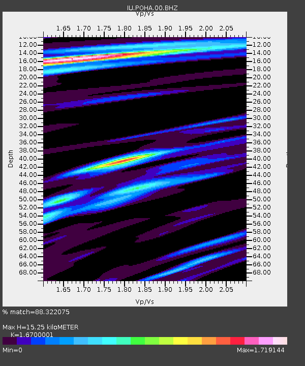
| Estimated Moho Depth: |
15.25 km |
| Estimated Crust Vp/Vs: |
1.67 |
| Assumed Crust Vp: |
5.195 km/s |
| Estimated Crust Vs: |
3.111 km/s |
| Estimated Crust Poisson's Ratio: |
0.22 |
|
| Radial Match: |
88.322075 % |
| Radial Bump: |
397 |
| Transverse Match: |
73.0536 % |
| Transverse Bump: |
400 |
| SOD ConfigId: |
739768 |
| Insert Time: |
2014-07-07 19:57:14.278 +0000 |
| GWidth: |
2.5 |
| Max Bumps: |
400 |
| Tol: |
0.001 |
|

Signal To Noise
| Channel | StoN | STA | LTA |
| IU:POHA:00:BHZ:20140623T19:28:07.969023Z | 3.0301201 | 1.5781025E-6 | 5.2080526E-7 |
| IU:POHA:00:BH1:20140623T19:28:07.969023Z | 0.8018934 | 9.845821E-7 | 1.2278216E-6 |
| IU:POHA:00:BH2:20140623T19:28:07.969023Z | 1.2481838 | 9.51749E-7 | 7.62507E-7 |
| Arrivals |
| Ps | 2.0 SECOND |
| PpPs | 7.6 SECOND |
| PsPs/PpSs | 9.6 SECOND |


