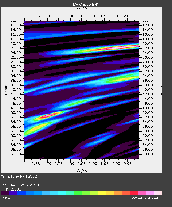
WRAB Tennant Creek, NT, Australia - Earthquake Result Viewer
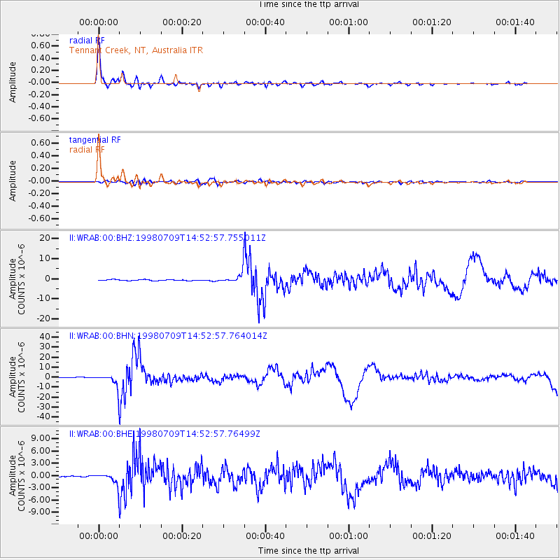
Earthquake location: Kermadec Islands, New Zealand
Earthquake latitude/longitude: -30.5/-179.0
Earthquake time(UTC): 1998/07/09 (190) 14:45:39 GMT
Earthquake Depth: 130 km
Earthquake Magnitude: 6.2 MB, 6.2 MS, 6.9 UNKNOWN, 6.4 ME
Earthquake Catalog/Contributor: WHDF/NEIC
Network: II Global Seismograph Network (GSN - IRIS/IDA)
Station: WRAB Tennant Creek, NT, Australia
Lat/Lon: 19.93 S/134.36 E
Elevation: 366 m
Distance: 43.2 deg
Az: 272.803 deg
Baz: 113.59 deg
Ray Param: 0.07220352
Estimated Moho Depth: 21.25 km
Estimated Crust Vp/Vs: 2.04
Assumed Crust Vp: 6.642 km/s
Estimated Crust Vs: 3.264 km/s
Estimated Crust Poisson's Ratio: 0.34
Radial Match: 97.15502 %
Radial Bump: 359
Transverse Match: 79.07236 %
Transverse Bump: 400
SOD ConfigId: 4480
Insert Time: 2010-03-01 23:20:07.639 +0000
GWidth: 2.5
Max Bumps: 400
Tol: 0.001

Signal To Noise

ChannelStoNSTALTA
II:WRAB:00:BHN:19980709T14:52:57.764014Z19.0340927.0311967E-63.6940017E-7
II:WRAB:00:BHE:19980709T14:52:57.76499Z8.9650951.4673624E-61.6367505E-7
II:WRAB:00:BHZ:19980709T14:52:57.755011Z13.9197473.2385906E-62.3266159E-7
Arrivals
Ps3.5 SECOND
PpPs9.1 SECOND
PsPs/PpSs13 SECOND