You are here: Home > Network List > UU - University of Utah Regional Network Stations List
> Station JLU Jordanelle, UT, USA > Earthquake Result Viewer
JLU Jordanelle, UT, USA - Earthquake Result Viewer
| Earthquake location: |
Kermadec Islands, New Zealand |
| Earthquake latitude/longitude: |
-30.1/-177.7 |
| Earthquake time(UTC): |
2014/06/23 (174) 19:19:16 GMT |
| Earthquake Depth: |
20 km |
| Earthquake Magnitude: |
6.9 MWW, 6.7 MWB, 7.2 MI |
| Earthquake Catalog/Contributor: |
NEIC PDE/NEIC COMCAT |
|
| Network: |
UU University of Utah Regional Network |
| Station: |
JLU Jordanelle, UT, USA |
| Lat/Lon: |
40.60 N/111.45 W |
| Elevation: |
2285 m |
|
| Distance: |
93.3 deg |
| Az: |
44.261 deg |
| Baz: |
232.581 deg |
| Ray Param: |
0.041282665 |
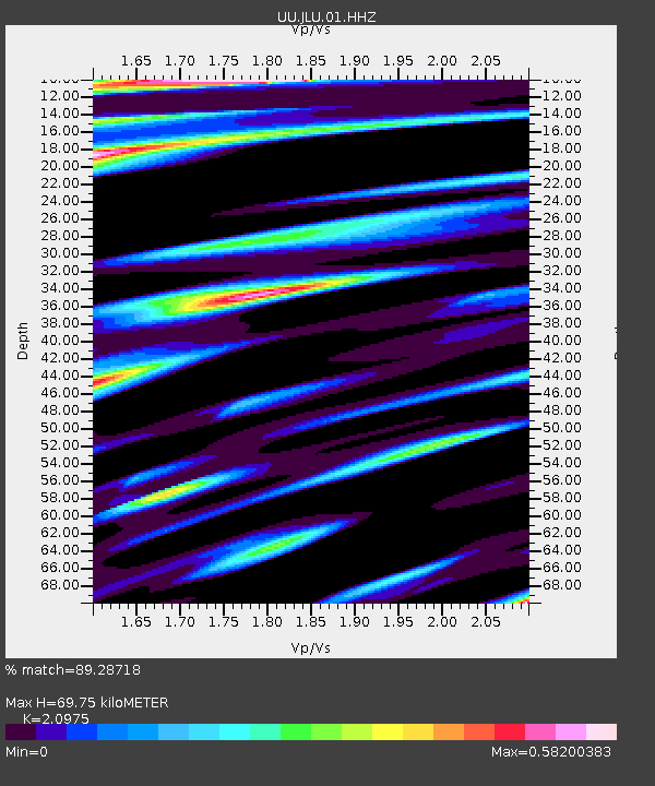
| Estimated Moho Depth: |
69.75 km |
| Estimated Crust Vp/Vs: |
2.10 |
| Assumed Crust Vp: |
6.155 km/s |
| Estimated Crust Vs: |
2.934 km/s |
| Estimated Crust Poisson's Ratio: |
0.35 |
|
| Radial Match: |
89.28718 % |
| Radial Bump: |
400 |
| Transverse Match: |
85.59343 % |
| Transverse Bump: |
400 |
| SOD ConfigId: |
739768 |
| Insert Time: |
2014-07-07 20:09:21.003 +0000 |
| GWidth: |
2.5 |
| Max Bumps: |
400 |
| Tol: |
0.001 |
|

Signal To Noise
| Channel | StoN | STA | LTA |
| UU:JLU:01:HHZ:20140623T19:31:58.180022Z | 6.41331 | 8.876499E-9 | 1.3840745E-9 |
| UU:JLU:01:HHN:20140623T19:31:58.180022Z | 1.312497 | 3.1104905E-9 | 2.369903E-9 |
| UU:JLU:01:HHE:20140623T19:31:58.180022Z | 1.6040372 | 3.38491E-9 | 2.110244E-9 |
| Arrivals |
| Ps | 13 SECOND |
| PpPs | 35 SECOND |
| PsPs/PpSs | 47 SECOND |


