You are here: Home > Network List > UW - Pacific Northwest Regional Seismic Network Stations List
> Station LON Longmire (broad-band and DWWSSN) > Earthquake Result Viewer
LON Longmire (broad-band and DWWSSN) - Earthquake Result Viewer
| Earthquake location: |
Kermadec Islands, New Zealand |
| Earthquake latitude/longitude: |
-30.1/-177.7 |
| Earthquake time(UTC): |
2014/06/23 (174) 19:19:16 GMT |
| Earthquake Depth: |
20 km |
| Earthquake Magnitude: |
6.9 MWW, 6.7 MWB, 7.2 MI |
| Earthquake Catalog/Contributor: |
NEIC PDE/NEIC COMCAT |
|
| Network: |
UW Pacific Northwest Regional Seismic Network |
| Station: |
LON Longmire (broad-band and DWWSSN) |
| Lat/Lon: |
46.75 N/121.81 W |
| Elevation: |
850 m |
|
| Distance: |
91.6 deg |
| Az: |
34.705 deg |
| Baz: |
225.842 deg |
| Ray Param: |
0.04157995 |
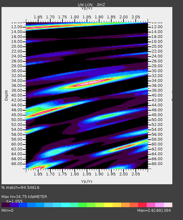
| Estimated Moho Depth: |
34.75 km |
| Estimated Crust Vp/Vs: |
1.86 |
| Assumed Crust Vp: |
6.597 km/s |
| Estimated Crust Vs: |
3.557 km/s |
| Estimated Crust Poisson's Ratio: |
0.30 |
|
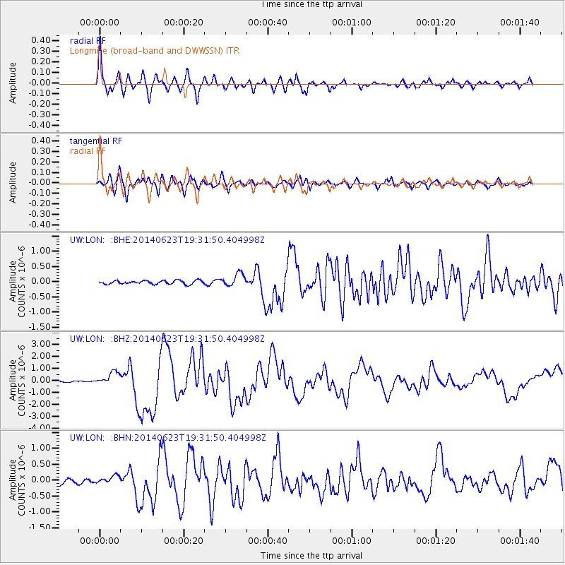
| Radial Match: |
94.54616 % |
| Radial Bump: |
400 |
| Transverse Match: |
82.315765 % |
| Transverse Bump: |
400 |
| SOD ConfigId: |
739768 |
| Insert Time: |
2014-07-07 20:11:54.873 +0000 |
| GWidth: |
2.5 |
| Max Bumps: |
400 |
| Tol: |
0.001 |
|
Signal To Noise
| Channel | StoN | STA | LTA |
| UW:LON: :BHZ:20140623T19:31:50.404998Z | 6.887691 | 5.740577E-7 | 8.334545E-8 |
| UW:LON: :BHN:20140623T19:31:50.404998Z | 1.7963088 | 1.2509533E-7 | 6.9640215E-8 |
| UW:LON: :BHE:20140623T19:31:50.404998Z | 3.683264 | 2.1563895E-7 | 5.8545613E-8 |
| Arrivals |
| Ps | 4.6 SECOND |
| PpPs | 15 SECOND |
| PsPs/PpSs | 19 SECOND |


