You are here: Home > Network List > TA - USArray Transportable Network (new EarthScope stations) Stations List
> Station G59A Clarenceville, QC, USA > Earthquake Result Viewer
G59A Clarenceville, QC, USA - Earthquake Result Viewer
| Earthquake location: |
Near Coast Of Central Chile |
| Earthquake latitude/longitude: |
-36.1/-73.7 |
| Earthquake time(UTC): |
2015/03/18 (077) 19:07:48 GMT |
| Earthquake Depth: |
10 km |
| Earthquake Magnitude: |
5.4 MW, 5.2 mb, 5.1 MS |
| Earthquake Catalog/Contributor: |
ISC/ISC |
|
| Network: |
TA USArray Transportable Network (new EarthScope stations) |
| Station: |
G59A Clarenceville, QC, USA |
| Lat/Lon: |
45.08 N/73.18 W |
| Elevation: |
36 m |
|
| Distance: |
80.8 deg |
| Az: |
0.386 deg |
| Baz: |
180.442 deg |
| Ray Param: |
0.048046827 |
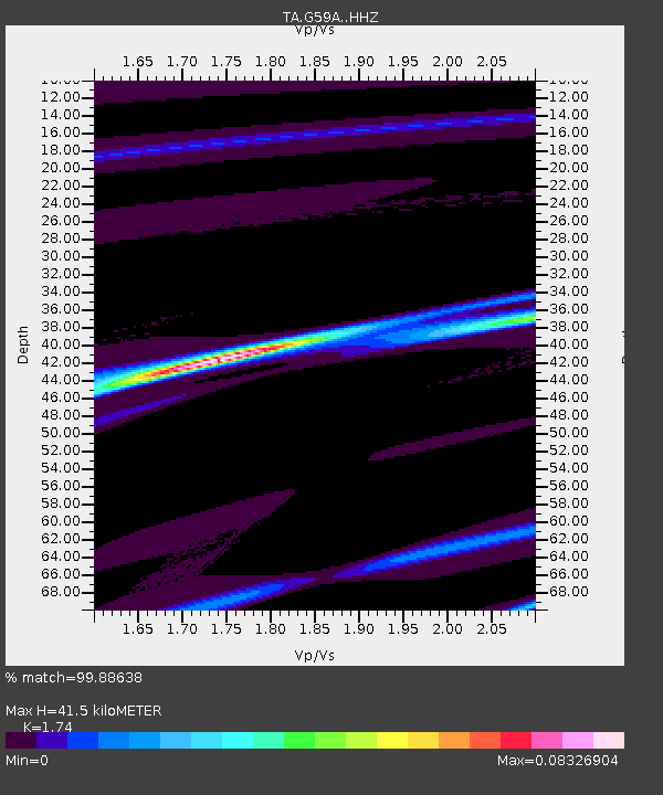
| Estimated Moho Depth: |
41.5 km |
| Estimated Crust Vp/Vs: |
1.74 |
| Assumed Crust Vp: |
6.419 km/s |
| Estimated Crust Vs: |
3.689 km/s |
| Estimated Crust Poisson's Ratio: |
0.25 |
|
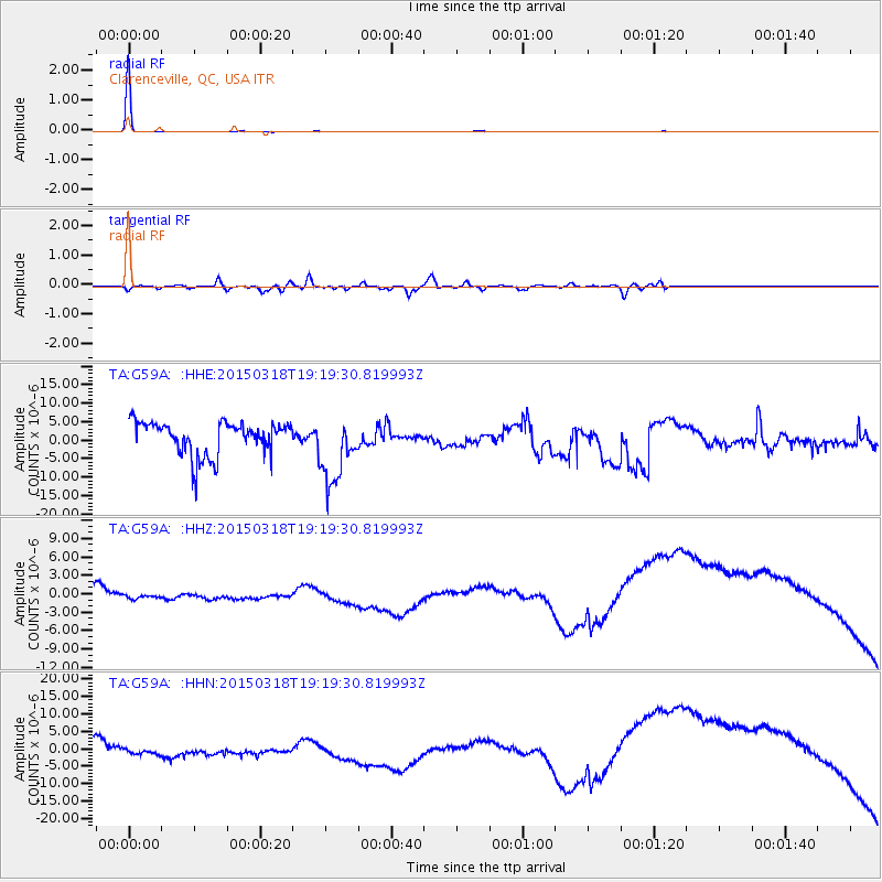
| Radial Match: |
99.88638 % |
| Radial Bump: |
19 |
| Transverse Match: |
57.04368 % |
| Transverse Bump: |
400 |
| SOD ConfigId: |
7422571 |
| Insert Time: |
2019-04-17 20:09:37.208 +0000 |
| GWidth: |
2.5 |
| Max Bumps: |
400 |
| Tol: |
0.001 |
|
Signal To Noise
| Channel | StoN | STA | LTA |
| TA:G59A: :HHZ:20150318T19:19:30.819993Z | 1.3063805 | 2.244663E-6 | 1.7182306E-6 |
| TA:G59A: :HHN:20150318T19:19:30.819993Z | 1.2829214 | 4.0571167E-6 | 3.1624045E-6 |
| TA:G59A: :HHE:20150318T19:19:30.819993Z | 2.092616 | 9.179544E-6 | 4.3866353E-6 |
| Arrivals |
| Ps | 4.9 SECOND |
| PpPs | 17 SECOND |
| PsPs/PpSs | 22 SECOND |


