You are here: Home > Network List > AV - Alaska Volcano Observatory Stations List
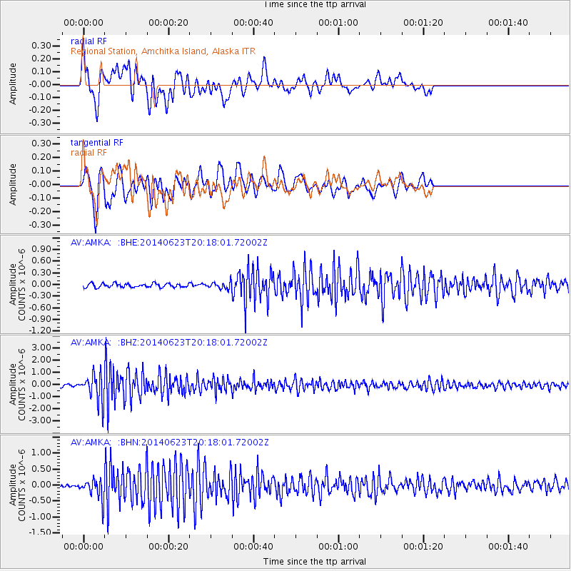
> Station AMKA Regional Station, Amchitka Island, Alaska > Earthquake Result Viewer
AMKA Regional Station, Amchitka Island, Alaska - Earthquake Result Viewer
| Earthquake location: |
Kermadec Islands, New Zealand |
| Earthquake latitude/longitude: |
-30.0/-177.5 |
| Earthquake time(UTC): |
2014/06/23 (174) 20:06:19 GMT |
| Earthquake Depth: |
20 km |
| Earthquake Magnitude: |
6.2 MB |
| Earthquake Catalog/Contributor: |
NEIC PDE/NEIC COMCAT |
|
| Network: |
AV Alaska Volcano Observatory |
| Station: |
AMKA Regional Station, Amchitka Island, Alaska |
| Lat/Lon: |
51.38 N/179.30 E |
| Elevation: |
116 m |
|
| Distance: |
81.0 deg |
| Az: |
357.986 deg |
| Baz: |
177.211 deg |
| Ray Param: |
0.0478515 |
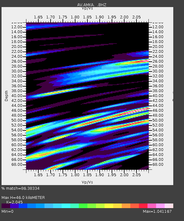
| Estimated Moho Depth: |
46.0 km |
| Estimated Crust Vp/Vs: |
2.05 |
| Assumed Crust Vp: |
6.183 km/s |
| Estimated Crust Vs: |
3.023 km/s |
| Estimated Crust Poisson's Ratio: |
0.34 |
|
| Radial Match: |
86.38334 % |
| Radial Bump: |
400 |
| Transverse Match: |
81.61118 % |
| Transverse Bump: |
400 |
| SOD ConfigId: |
739768 |
| Insert Time: |
2014-07-07 20:19:13.278 +0000 |
| GWidth: |
2.5 |
| Max Bumps: |
400 |
| Tol: |
0.001 |
|
Signal To Noise
| Channel | StoN | STA | LTA |
| AV:AMKA: :BHZ:20140623T20:18:01.72002Z | 19.98624 | 1.1439444E-6 | 5.7236594E-8 |
| AV:AMKA: :BHN:20140623T20:18:01.72002Z | 7.4075866 | 3.2786284E-7 | 4.426041E-8 |
| AV:AMKA: :BHE:20140623T20:18:01.72002Z | 1.7536353 | 8.626386E-8 | 4.9191446E-8 |
| Arrivals |
| Ps | 7.9 SECOND |
| PpPs | 22 SECOND |
| PsPs/PpSs | 30 SECOND |


