You are here: Home > Network List > AU - Australian Seismological Centre Stations List
> Station XMIS Christmas Island Grants Well > Earthquake Result Viewer
XMIS Christmas Island Grants Well - Earthquake Result Viewer
| Earthquake location: |
Rat Islands, Aleutian Islands |
| Earthquake latitude/longitude: |
51.8/178.8 |
| Earthquake time(UTC): |
2014/06/23 (174) 20:53:09 GMT |
| Earthquake Depth: |
108 km |
| Earthquake Magnitude: |
7.9 MWW, 7.1 MI, 7.9 MWC |
| Earthquake Catalog/Contributor: |
NEIC PDE/NEIC COMCAT |
|
| Network: |
AU Australian Seismological Centre |
| Station: |
XMIS Christmas Island Grants Well |
| Lat/Lon: |
10.48 S/105.65 E |
| Elevation: |
210 m |
|
| Distance: |
87.9 deg |
| Az: |
250.34 deg |
| Baz: |
36.484 deg |
| Ray Param: |
0.042723168 |
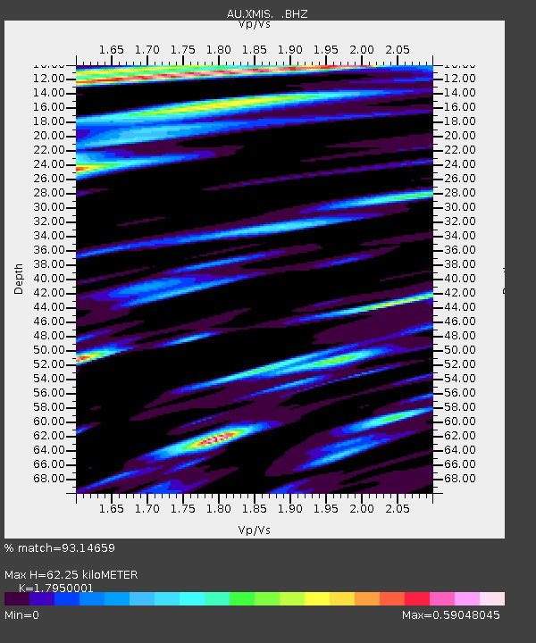
| Estimated Moho Depth: |
62.25 km |
| Estimated Crust Vp/Vs: |
1.80 |
| Assumed Crust Vp: |
4.157 km/s |
| Estimated Crust Vs: |
2.316 km/s |
| Estimated Crust Poisson's Ratio: |
0.27 |
|
| Radial Match: |
93.14659 % |
| Radial Bump: |
307 |
| Transverse Match: |
58.542343 % |
| Transverse Bump: |
400 |
| SOD ConfigId: |
739768 |
| Insert Time: |
2014-07-07 20:57:38.780 +0000 |
| GWidth: |
2.5 |
| Max Bumps: |
400 |
| Tol: |
0.001 |
|

Signal To Noise
| Channel | StoN | STA | LTA |
| AU:XMIS: :BHZ:20140623T21:05:16.594014Z | 2.3572004 | 6.249667E-6 | 2.6513092E-6 |
| AU:XMIS: :BHN:20140623T21:05:16.594014Z | 2.31032 | 4.377327E-6 | 1.8946845E-6 |
| AU:XMIS: :BHE:20140623T21:05:16.594014Z | 1.8158 | 4.682301E-6 | 2.5786437E-6 |
| Arrivals |
| Ps | 12 SECOND |
| PpPs | 41 SECOND |
| PsPs/PpSs | 53 SECOND |


