You are here: Home > Network List > CC - Cascade Chain Volcano Monitoring Stations List
> Station STD Studebaker Ridge, Mount St Helens, WA > Earthquake Result Viewer
STD Studebaker Ridge, Mount St Helens, WA - Earthquake Result Viewer
| Earthquake location: |
Rat Islands, Aleutian Islands |
| Earthquake latitude/longitude: |
51.8/178.8 |
| Earthquake time(UTC): |
2014/06/23 (174) 20:53:09 GMT |
| Earthquake Depth: |
108 km |
| Earthquake Magnitude: |
7.9 MWW, 7.1 MI, 7.9 MWC |
| Earthquake Catalog/Contributor: |
NEIC PDE/NEIC COMCAT |
|
| Network: |
CC Cascade Chain Volcano Monitoring |
| Station: |
STD Studebaker Ridge, Mount St Helens, WA |
| Lat/Lon: |
46.24 N/122.22 W |
| Elevation: |
1268 m |
|
| Distance: |
38.2 deg |
| Az: |
74.324 deg |
| Baz: |
300.522 deg |
| Ray Param: |
0.07534992 |
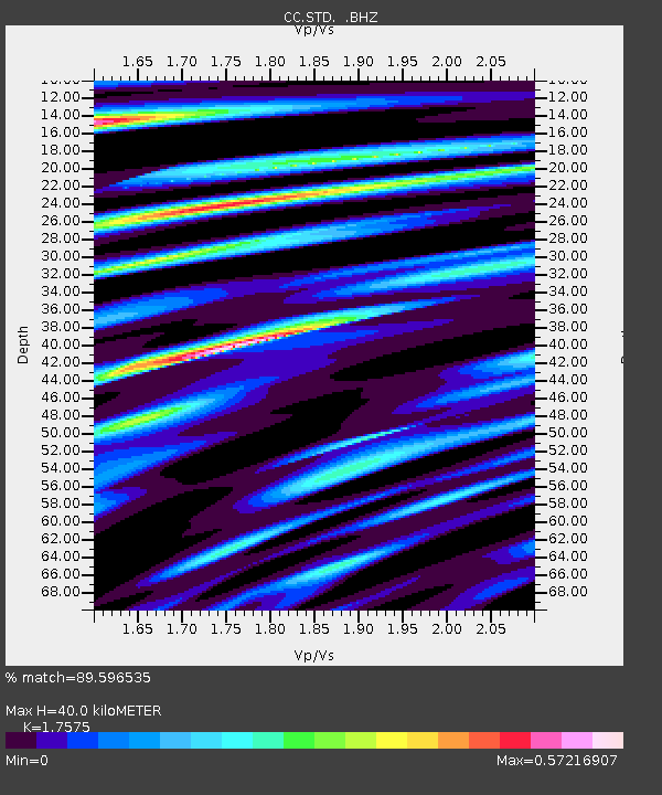
| Estimated Moho Depth: |
40.0 km |
| Estimated Crust Vp/Vs: |
1.76 |
| Assumed Crust Vp: |
6.566 km/s |
| Estimated Crust Vs: |
3.736 km/s |
| Estimated Crust Poisson's Ratio: |
0.26 |
|
| Radial Match: |
89.596535 % |
| Radial Bump: |
400 |
| Transverse Match: |
75.08292 % |
| Transverse Bump: |
400 |
| SOD ConfigId: |
739768 |
| Insert Time: |
2014-07-07 21:00:10.371 +0000 |
| GWidth: |
2.5 |
| Max Bumps: |
400 |
| Tol: |
0.001 |
|

Signal To Noise
| Channel | StoN | STA | LTA |
| CC:STD: :BHZ:20140623T20:59:48.620015Z | 3.8192146 | 6.488621E-6 | 1.6989412E-6 |
| CC:STD: :BHN:20140623T20:59:48.620015Z | 1.1699196 | 1.5360644E-6 | 1.3129659E-6 |
| CC:STD: :BHE:20140623T20:59:48.620015Z | 3.6934755 | 1.743933E-6 | 4.7216585E-7 |
| Arrivals |
| Ps | 5.0 SECOND |
| PpPs | 16 SECOND |
| PsPs/PpSs | 21 SECOND |


