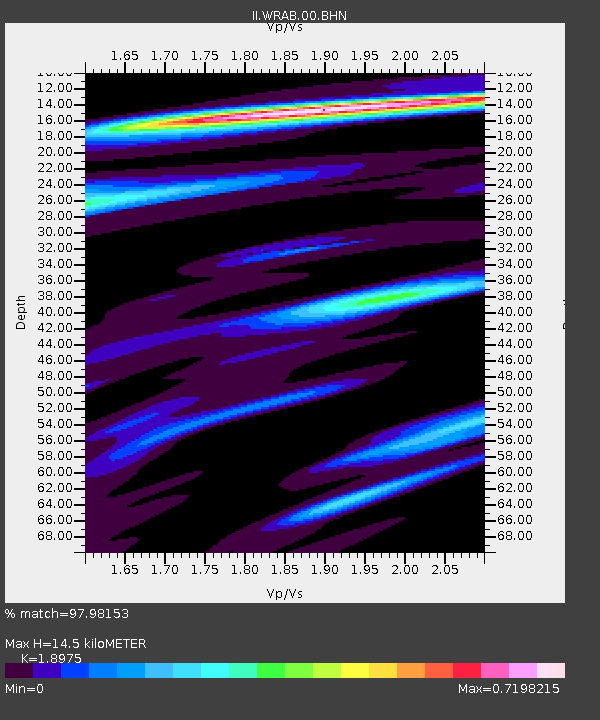
WRAB Tennant Creek, NT, Australia - Earthquake Result Viewer
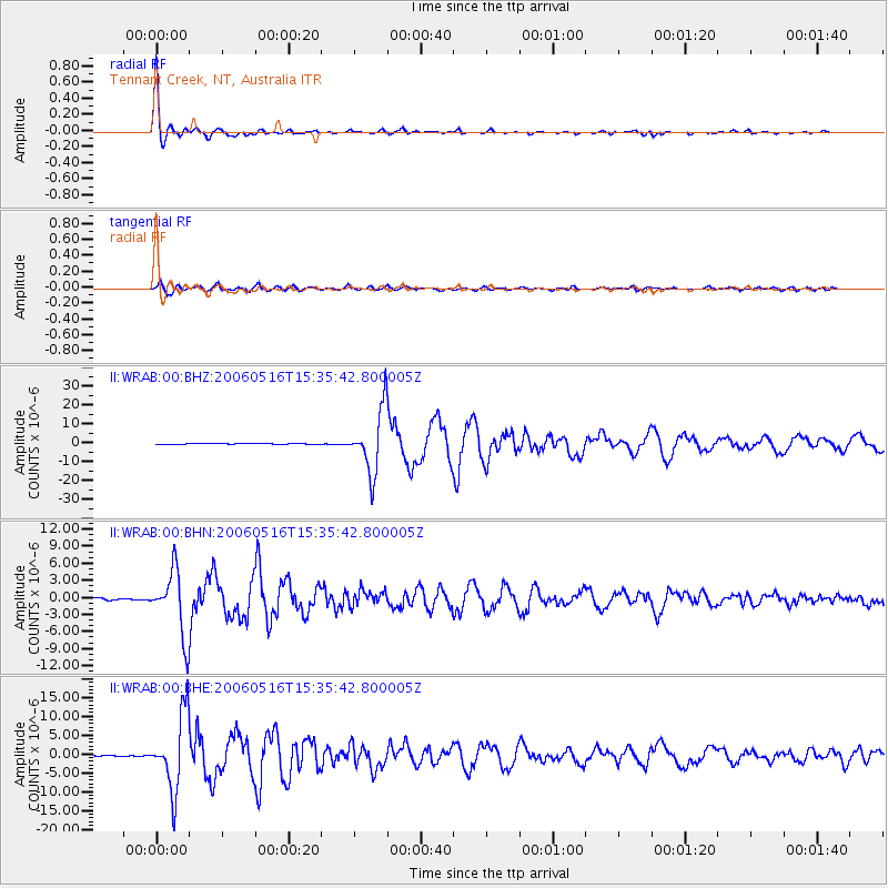
Earthquake location: Northern Sumatra, Indonesia
Earthquake latitude/longitude: 0.1/97.1
Earthquake time(UTC): 2006/05/16 (136) 15:28:25 GMT
Earthquake Depth: 12 km
Earthquake Magnitude: 6.6 MB, 6.8 MS, 6.8 MW, 6.8 MW
Earthquake Catalog/Contributor: WHDF/NEIC
Network: II Global Seismograph Network (GSN - IRIS/IDA)
Station: WRAB Tennant Creek, NT, Australia
Lat/Lon: 19.93 S/134.36 E
Elevation: 366 m
Distance: 41.6 deg
Az: 120.813 deg
Baz: 294.095 deg
Ray Param: 0.07368209
Estimated Moho Depth: 14.5 km
Estimated Crust Vp/Vs: 1.90
Assumed Crust Vp: 6.642 km/s
Estimated Crust Vs: 3.5 km/s
Estimated Crust Poisson's Ratio: 0.31
Radial Match: 97.98153 %
Radial Bump: 231
Transverse Match: 89.78911 %
Transverse Bump: 400
SOD ConfigId: 2669
Insert Time: 2010-03-01 23:22:18.109 +0000
GWidth: 2.5
Max Bumps: 400
Tol: 0.001

Signal To Noise

ChannelStoNSTALTA
II:WRAB:00:BHN:20060516T15:35:42.800005Z36.878595.622096E-61.5244878E-7
II:WRAB:00:BHE:20060516T15:35:42.800005Z91.8329549.878239E-61.0756749E-7
II:WRAB:00:BHZ:20060516T15:35:42.800005Z105.702831.6610407E-51.571425E-7
Arrivals
Ps2.1 SECOND
PpPs5.9 SECOND
PsPs/PpSs8.0 SECOND