You are here: Home > Network List > II - Global Seismograph Network (GSN - IRIS/IDA) Stations List
> Station WRAB Tennant Creek, NT, Australia > Earthquake Result Viewer
WRAB Tennant Creek, NT, Australia - Earthquake Result Viewer
| Earthquake location: |
Eastern Siberia, Russia |
| Earthquake latitude/longitude: |
60.9/167.1 |
| Earthquake time(UTC): |
2006/04/20 (110) 23:25:02 GMT |
| Earthquake Depth: |
22 km |
| Earthquake Magnitude: |
6.8 MB, 7.6 MS, 7.6 MW, 7.3 MW |
| Earthquake Catalog/Contributor: |
WHDF/NEIC |
|
| Network: |
II Global Seismograph Network (GSN - IRIS/IDA) |
| Station: |
WRAB Tennant Creek, NT, Australia |
| Lat/Lon: |
19.93 S/134.36 E |
| Elevation: |
366 m |
|
| Distance: |
84.8 deg |
| Az: |
210.715 deg |
| Baz: |
15.366 deg |
| Ray Param: |
0.045195483 |
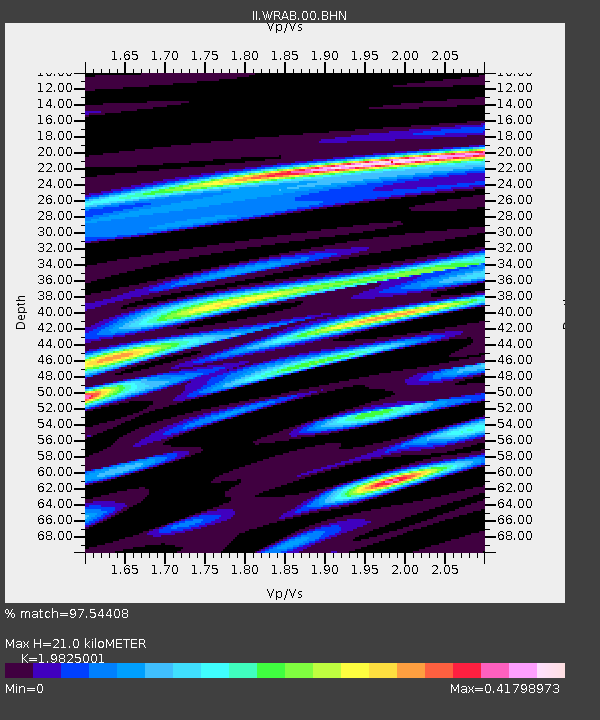
| Estimated Moho Depth: |
21.0 km |
| Estimated Crust Vp/Vs: |
1.98 |
| Assumed Crust Vp: |
6.642 km/s |
| Estimated Crust Vs: |
3.35 km/s |
| Estimated Crust Poisson's Ratio: |
0.33 |
|
| Radial Match: |
97.54408 % |
| Radial Bump: |
316 |
| Transverse Match: |
88.68808 % |
| Transverse Bump: |
400 |
| SOD ConfigId: |
2669 |
| Insert Time: |
2010-03-01 23:22:23.606 +0000 |
| GWidth: |
2.5 |
| Max Bumps: |
400 |
| Tol: |
0.001 |
|
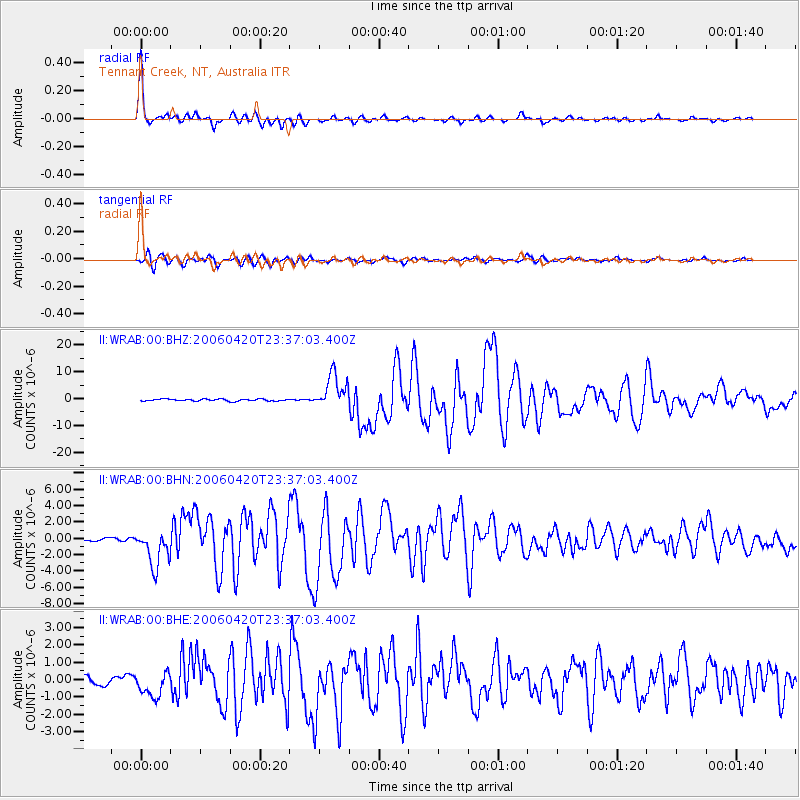
Signal To Noise
| Channel | StoN | STA | LTA |
| II:WRAB:00:BHN:20060420T23:37:03.400Z | 6.318364 | 2.2832862E-6 | 3.61373E-7 |
| II:WRAB:00:BHE:20060420T23:37:03.400Z | 1.9071716 | 7.041064E-7 | 3.691888E-7 |
| II:WRAB:00:BHZ:20060420T23:37:03.400Z | 17.376604 | 6.277584E-6 | 3.6126644E-7 |
| Arrivals |
| Ps | 3.2 SECOND |
| PpPs | 9.2 SECOND |
| PsPs/PpSs | 12 SECOND |


