You are here: Home > Network List > G - GEOSCOPE Stations List
> Station PPTF Pamatai - Papeete - Tahiti island - French Polynesia, France > Earthquake Result Viewer
PPTF Pamatai - Papeete - Tahiti island - French Polynesia, France - Earthquake Result Viewer
| Earthquake location: |
Rat Islands, Aleutian Islands |
| Earthquake latitude/longitude: |
51.8/178.8 |
| Earthquake time(UTC): |
2014/06/23 (174) 20:53:09 GMT |
| Earthquake Depth: |
108 km |
| Earthquake Magnitude: |
7.9 MWW, 7.1 MI, 7.9 MWC |
| Earthquake Catalog/Contributor: |
NEIC PDE/NEIC COMCAT |
|
| Network: |
G GEOSCOPE |
| Station: |
PPTF Pamatai - Papeete - Tahiti island - French Polynesia, France |
| Lat/Lon: |
17.59 S/149.57 W |
| Elevation: |
705 m |
|
| Distance: |
74.4 deg |
| Az: |
148.67 deg |
| Baz: |
340.212 deg |
| Ray Param: |
0.052090075 |
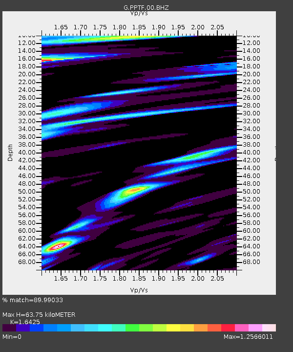
| Estimated Moho Depth: |
63.75 km |
| Estimated Crust Vp/Vs: |
1.64 |
| Assumed Crust Vp: |
4.24 km/s |
| Estimated Crust Vs: |
2.581 km/s |
| Estimated Crust Poisson's Ratio: |
0.21 |
|
| Radial Match: |
89.99033 % |
| Radial Bump: |
400 |
| Transverse Match: |
86.87374 % |
| Transverse Bump: |
400 |
| SOD ConfigId: |
739768 |
| Insert Time: |
2014-07-07 21:08:32.583 +0000 |
| GWidth: |
2.5 |
| Max Bumps: |
400 |
| Tol: |
0.001 |
|
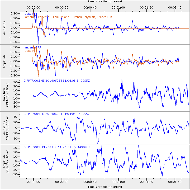
Signal To Noise
| Channel | StoN | STA | LTA |
| G:PPTF:00:BHZ:20140623T21:04:05.349995Z | 2.6887548 | 5.6103736E-6 | 2.0866064E-6 |
| G:PPTF:00:BHN:20140623T21:04:05.349995Z | 0.7585681 | 3.0230913E-6 | 3.98526E-6 |
| G:PPTF:00:BHE:20140623T21:04:05.349995Z | 1.1334153 | 4.039085E-6 | 3.5636406E-6 |
| Arrivals |
| Ps | 9.8 SECOND |
| PpPs | 39 SECOND |
| PsPs/PpSs | 49 SECOND |


