You are here: Home > Network List > G - GEOSCOPE Stations List
> Station SANVU Espiritu Santo, Vanuatu > Earthquake Result Viewer
SANVU Espiritu Santo, Vanuatu - Earthquake Result Viewer
| Earthquake location: |
Rat Islands, Aleutian Islands |
| Earthquake latitude/longitude: |
51.8/178.8 |
| Earthquake time(UTC): |
2014/06/23 (174) 20:53:09 GMT |
| Earthquake Depth: |
108 km |
| Earthquake Magnitude: |
7.9 MWW, 7.1 MI, 7.9 MWC |
| Earthquake Catalog/Contributor: |
NEIC PDE/NEIC COMCAT |
|
| Network: |
G GEOSCOPE |
| Station: |
SANVU Espiritu Santo, Vanuatu |
| Lat/Lon: |
15.45 S/167.20 E |
| Elevation: |
56 m |
|
| Distance: |
67.7 deg |
| Az: |
192.052 deg |
| Baz: |
7.728 deg |
| Ray Param: |
0.056499496 |
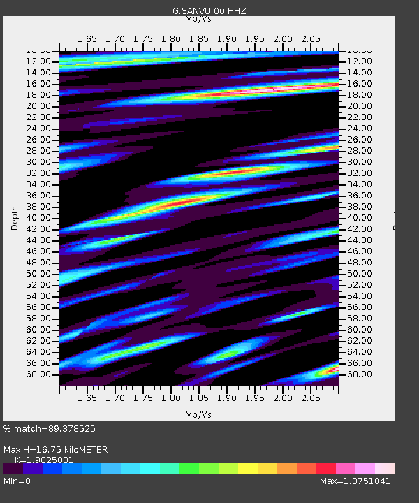
| Estimated Moho Depth: |
16.75 km |
| Estimated Crust Vp/Vs: |
1.98 |
| Assumed Crust Vp: |
4.802 km/s |
| Estimated Crust Vs: |
2.422 km/s |
| Estimated Crust Poisson's Ratio: |
0.33 |
|
| Radial Match: |
89.378525 % |
| Radial Bump: |
400 |
| Transverse Match: |
85.36419 % |
| Transverse Bump: |
400 |
| SOD ConfigId: |
739768 |
| Insert Time: |
2014-07-07 21:08:35.543 +0000 |
| GWidth: |
2.5 |
| Max Bumps: |
400 |
| Tol: |
0.001 |
|

Signal To Noise
| Channel | StoN | STA | LTA |
| G:SANVU:00:HHZ:20140623T21:03:24.998982Z | 5.9398007 | 1.3043649E-5 | 2.1959743E-6 |
| G:SANVU:00:HHN:20140623T21:03:24.998982Z | 6.462556 | 6.7008555E-6 | 1.0368739E-6 |
| G:SANVU:00:HHE:20140623T21:03:24.998982Z | 1.6664933 | 3.878381E-6 | 2.3272705E-6 |
| Arrivals |
| Ps | 3.5 SECOND |
| PpPs | 10 SECOND |
| PsPs/PpSs | 14 SECOND |


