You are here: Home > Network List > HV - Hawaiian Volcano Observatory Network Stations List
> Station MLOD Mauna Loa, Hawaii Digital > Earthquake Result Viewer
MLOD Mauna Loa, Hawaii Digital - Earthquake Result Viewer
| Earthquake location: |
Rat Islands, Aleutian Islands |
| Earthquake latitude/longitude: |
51.8/178.8 |
| Earthquake time(UTC): |
2014/06/23 (174) 20:53:09 GMT |
| Earthquake Depth: |
108 km |
| Earthquake Magnitude: |
7.9 MWW, 7.1 MI, 7.9 MWC |
| Earthquake Catalog/Contributor: |
NEIC PDE/NEIC COMCAT |
|
| Network: |
HV Hawaiian Volcano Observatory Network |
| Station: |
MLOD Mauna Loa, Hawaii Digital |
| Lat/Lon: |
19.49 N/155.39 W |
| Elevation: |
2044 m |
|
| Distance: |
38.1 deg |
| Az: |
138.158 deg |
| Baz: |
333.952 deg |
| Ray Param: |
0.07540612 |
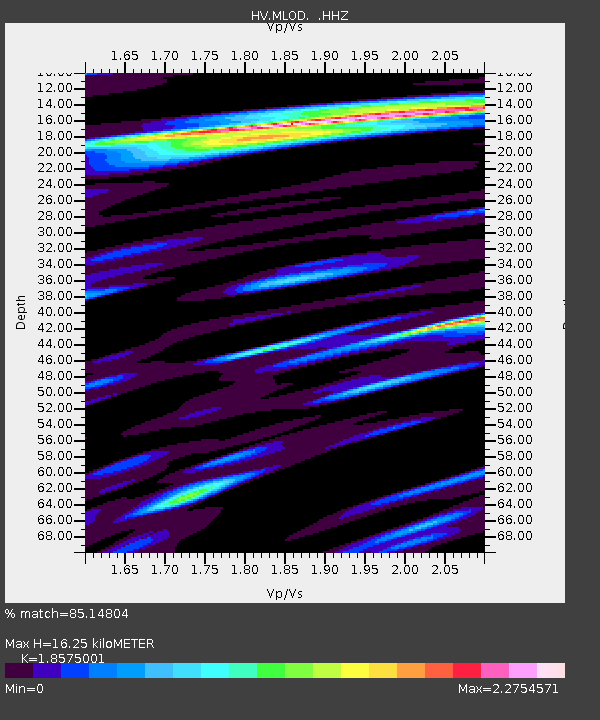
| Estimated Moho Depth: |
16.25 km |
| Estimated Crust Vp/Vs: |
1.86 |
| Assumed Crust Vp: |
5.195 km/s |
| Estimated Crust Vs: |
2.797 km/s |
| Estimated Crust Poisson's Ratio: |
0.30 |
|
| Radial Match: |
85.14804 % |
| Radial Bump: |
400 |
| Transverse Match: |
85.9877 % |
| Transverse Bump: |
400 |
| SOD ConfigId: |
739768 |
| Insert Time: |
2014-07-07 21:12:56.971 +0000 |
| GWidth: |
2.5 |
| Max Bumps: |
400 |
| Tol: |
0.001 |
|
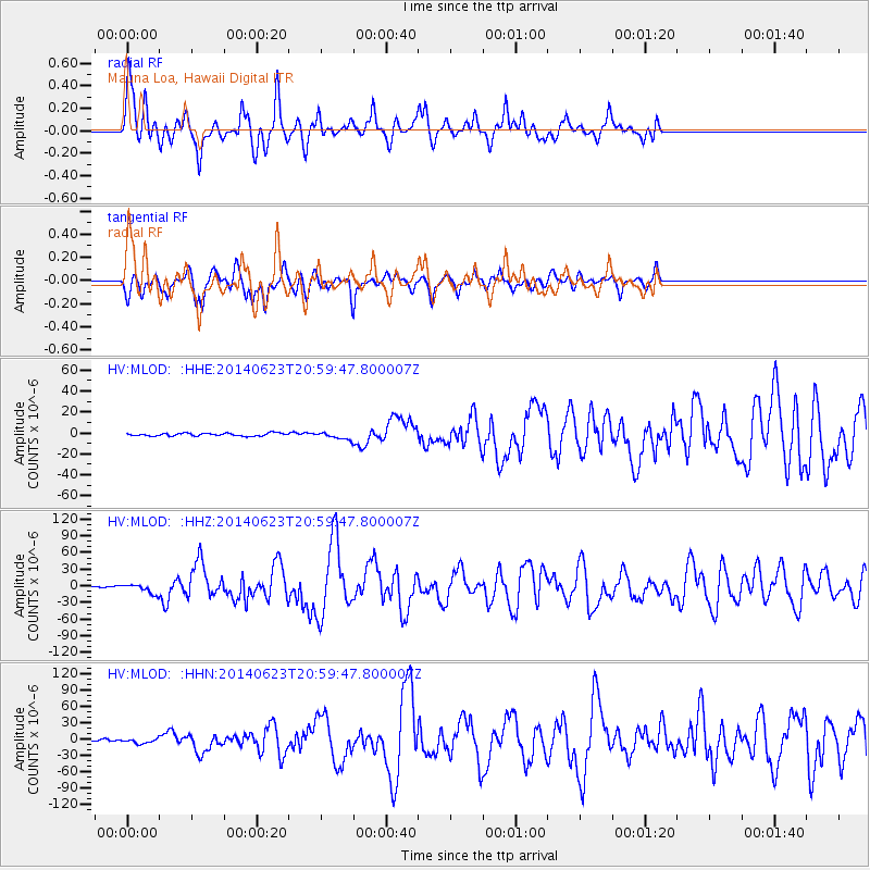
Signal To Noise
| Channel | StoN | STA | LTA |
| HV:MLOD: :HHZ:20140623T20:59:47.800007Z | 6.487222 | 8.390758E-6 | 1.2934285E-6 |
| HV:MLOD: :HHN:20140623T20:59:47.800007Z | 1.1877148 | 3.9085435E-6 | 3.2908097E-6 |
| HV:MLOD: :HHE:20140623T20:59:47.800007Z | 2.4825735 | 3.3344154E-6 | 1.3431286E-6 |
| Arrivals |
| Ps | 2.8 SECOND |
| PpPs | 8.6 SECOND |
| PsPs/PpSs | 11 SECOND |


