You are here: Home > Network List > HV - Hawaiian Volcano Observatory Network Stations List
> Station MOKD Mokuaweoweo, Hawaii Digital > Earthquake Result Viewer
MOKD Mokuaweoweo, Hawaii Digital - Earthquake Result Viewer
| Earthquake location: |
Rat Islands, Aleutian Islands |
| Earthquake latitude/longitude: |
51.8/178.8 |
| Earthquake time(UTC): |
2014/06/23 (174) 20:53:09 GMT |
| Earthquake Depth: |
108 km |
| Earthquake Magnitude: |
7.9 MWW, 7.1 MI, 7.9 MWC |
| Earthquake Catalog/Contributor: |
NEIC PDE/NEIC COMCAT |
|
| Network: |
HV Hawaiian Volcano Observatory Network |
| Station: |
MOKD Mokuaweoweo, Hawaii Digital |
| Lat/Lon: |
19.49 N/155.60 W |
| Elevation: |
4102 m |
|
| Distance: |
38.0 deg |
| Az: |
138.454 deg |
| Baz: |
334.115 deg |
| Ray Param: |
0.07545199 |
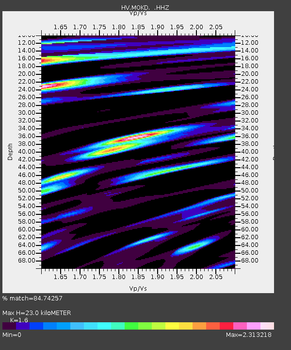
| Estimated Moho Depth: |
23.0 km |
| Estimated Crust Vp/Vs: |
1.60 |
| Assumed Crust Vp: |
5.195 km/s |
| Estimated Crust Vs: |
3.247 km/s |
| Estimated Crust Poisson's Ratio: |
0.18 |
|
| Radial Match: |
84.74257 % |
| Radial Bump: |
400 |
| Transverse Match: |
64.75 % |
| Transverse Bump: |
400 |
| SOD ConfigId: |
739768 |
| Insert Time: |
2014-07-07 21:13:01.457 +0000 |
| GWidth: |
2.5 |
| Max Bumps: |
400 |
| Tol: |
0.001 |
|

Signal To Noise
| Channel | StoN | STA | LTA |
| HV:MOKD: :HHZ:20140623T20:59:47.129994Z | 3.7252555 | 7.749537E-6 | 2.08027E-6 |
| HV:MOKD: :HHN:20140623T20:59:47.129994Z | 1.3588763 | 4.238026E-6 | 3.1187724E-6 |
| HV:MOKD: :HHE:20140623T20:59:47.129994Z | 1.742996 | 3.820339E-6 | 2.1918231E-6 |
| Arrivals |
| Ps | 2.8 SECOND |
| PpPs | 11 SECOND |
| PsPs/PpSs | 14 SECOND |


