You are here: Home > Network List > IU - Global Seismograph Network (GSN - IRIS/USGS) Stations List
> Station GUMO Guam, Mariana Islands > Earthquake Result Viewer
GUMO Guam, Mariana Islands - Earthquake Result Viewer

| Earthquake location: |
Rat Islands, Aleutian Islands |
| Earthquake latitude/longitude: |
51.8/178.8 |
| Earthquake time(UTC): |
2014/06/23 (174) 20:53:09 GMT |
| Earthquake Depth: |
108 km |
| Earthquake Magnitude: |
7.9 MWW, 7.1 MI, 7.9 MWC |
| Earthquake Catalog/Contributor: |
NEIC PDE/NEIC COMCAT |
|
| Network: |
IU Global Seismograph Network (GSN - IRIS/USGS) |
| Station: |
GUMO Guam, Mariana Islands |
| Lat/Lon: |
13.59 N/144.87 E |
| Elevation: |
170 m |
|
| Distance: |
46.8 deg |
| Az: |
228.033 deg |
| Baz: |
28.35 deg |
| Ray Param: |
0.0700214 |
| Estimated Moho Depth: |
63.75 km |
| Estimated Crust Vp/Vs: |
1.75 |
| Assumed Crust Vp: |
4.802 km/s |
| Estimated Crust Vs: |
2.744 km/s |
| Estimated Crust Poisson's Ratio: |
0.26 |
|
| Radial Match: |
90.2318 % |
| Radial Bump: |
400 |
| Transverse Match: |
87.6525 % |
| Transverse Bump: |
400 |
| SOD ConfigId: |
739768 |
| Insert Time: |
2014-07-07 21:16:19.650 +0000 |
| GWidth: |
2.5 |
| Max Bumps: |
400 |
| Tol: |
0.001 |
|
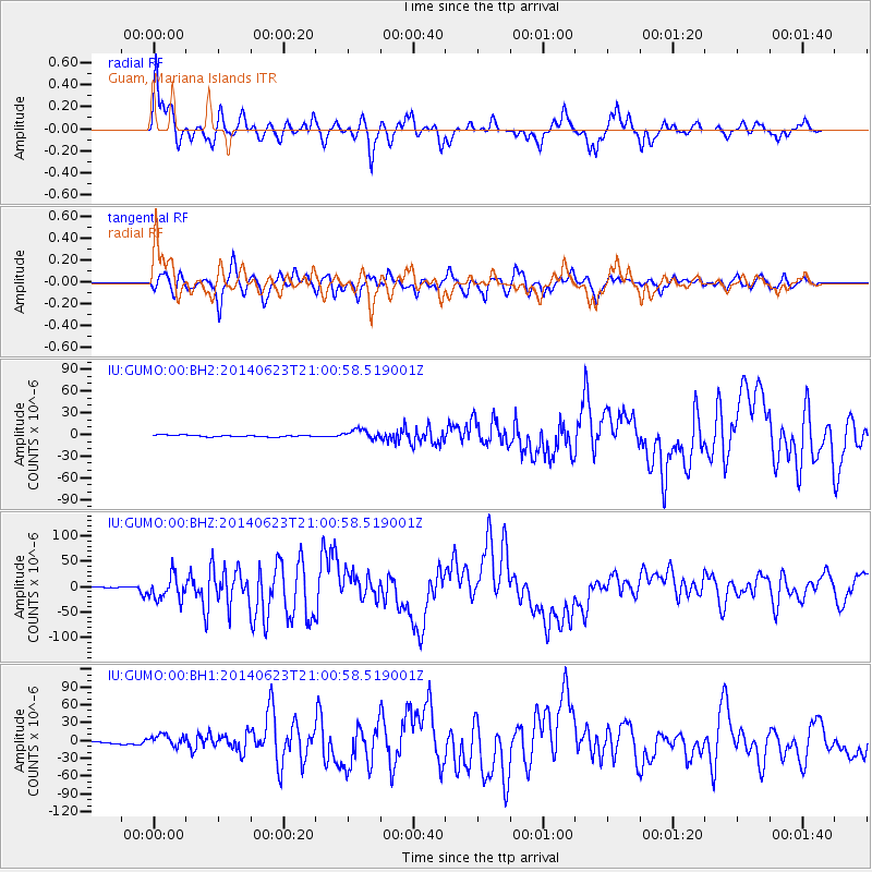
Signal To Noise
| Channel | StoN | STA | LTA |
| IU:GUMO:00:BHZ:20140623T21:00:58.519001Z | 11.571629 | 2.316558E-5 | 2.001929E-6 |
| IU:GUMO:00:BH1:20140623T21:00:58.519001Z | 6.966311 | 9.333714E-6 | 1.339836E-6 |
| IU:GUMO:00:BH2:20140623T21:00:58.519001Z | 6.044832 | 6.7376877E-6 | 1.1146195E-6 |
| Arrivals |
| Ps | 10 SECOND |
| PpPs | 35 SECOND |
| PsPs/PpSs | 46 SECOND |


