You are here: Home > Network List > IU - Global Seismograph Network (GSN - IRIS/USGS) Stations List
> Station TEIG Tepich, Yucatan, Mexico > Earthquake Result Viewer
TEIG Tepich, Yucatan, Mexico - Earthquake Result Viewer
| Earthquake location: |
Rat Islands, Aleutian Islands |
| Earthquake latitude/longitude: |
51.8/178.8 |
| Earthquake time(UTC): |
2014/06/23 (174) 20:53:09 GMT |
| Earthquake Depth: |
108 km |
| Earthquake Magnitude: |
7.9 MWW, 7.1 MI, 7.9 MWC |
| Earthquake Catalog/Contributor: |
NEIC PDE/NEIC COMCAT |
|
| Network: |
IU Global Seismograph Network (GSN - IRIS/USGS) |
| Station: |
TEIG Tepich, Yucatan, Mexico |
| Lat/Lon: |
20.23 N/88.28 W |
| Elevation: |
40 m |
|
| Distance: |
76.2 deg |
| Az: |
74.989 deg |
| Baz: |
320.303 deg |
| Ray Param: |
0.050929453 |
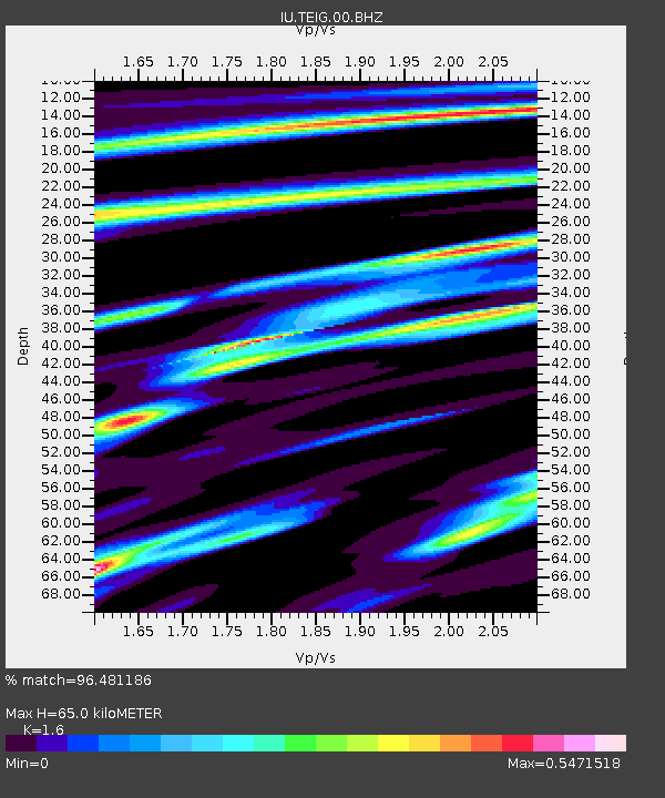
| Estimated Moho Depth: |
65.0 km |
| Estimated Crust Vp/Vs: |
1.60 |
| Assumed Crust Vp: |
5.817 km/s |
| Estimated Crust Vs: |
3.636 km/s |
| Estimated Crust Poisson's Ratio: |
0.18 |
|
| Radial Match: |
96.481186 % |
| Radial Bump: |
303 |
| Transverse Match: |
96.46679 % |
| Transverse Bump: |
345 |
| SOD ConfigId: |
739768 |
| Insert Time: |
2014-07-07 21:17:35.130 +0000 |
| GWidth: |
2.5 |
| Max Bumps: |
400 |
| Tol: |
0.001 |
|

Signal To Noise
| Channel | StoN | STA | LTA |
| IU:TEIG:00:BHZ:20140623T21:04:15.310017Z | 4.699179 | 4.3885525E-6 | 9.3389764E-7 |
| IU:TEIG:00:BH1:20140623T21:04:15.310017Z | 2.215328 | 4.4826432E-8 | 2.023467E-8 |
| IU:TEIG:00:BH2:20140623T21:04:15.310017Z | 1.4957359 | 1.9447032E-6 | 1.3001649E-6 |
| Arrivals |
| Ps | 6.9 SECOND |
| PpPs | 28 SECOND |
| PsPs/PpSs | 35 SECOND |


