You are here: Home > Network List > II - Global Seismograph Network (GSN - IRIS/IDA) Stations List
> Station WRAB Tennant Creek, NT, Australia > Earthquake Result Viewer
WRAB Tennant Creek, NT, Australia - Earthquake Result Viewer
| Earthquake location: |
Myanmar |
| Earthquake latitude/longitude: |
26.9/97.2 |
| Earthquake time(UTC): |
2000/06/07 (159) 21:46:55 GMT |
| Earthquake Depth: |
33 km |
| Earthquake Magnitude: |
6.3 MB, 6.5 MS, 6.4 MW, 6.4 MW |
| Earthquake Catalog/Contributor: |
WHDF/NEIC |
|
| Network: |
II Global Seismograph Network (GSN - IRIS/IDA) |
| Station: |
WRAB Tennant Creek, NT, Australia |
| Lat/Lon: |
19.93 S/134.36 E |
| Elevation: |
366 m |
|
| Distance: |
58.8 deg |
| Az: |
138.414 deg |
| Baz: |
320.931 deg |
| Ray Param: |
0.06254495 |
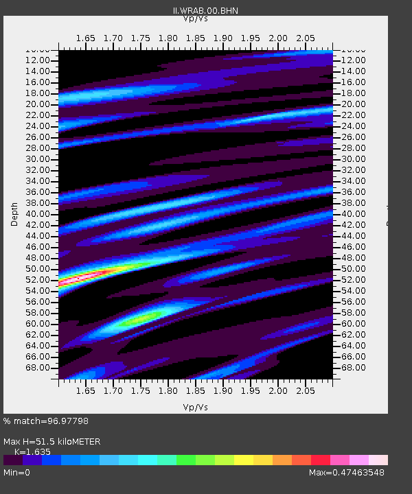
| Estimated Moho Depth: |
51.5 km |
| Estimated Crust Vp/Vs: |
1.63 |
| Assumed Crust Vp: |
6.642 km/s |
| Estimated Crust Vs: |
4.062 km/s |
| Estimated Crust Poisson's Ratio: |
0.20 |
|
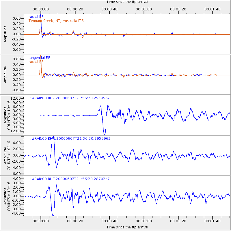
| Radial Match: |
96.97798 % |
| Radial Bump: |
252 |
| Transverse Match: |
85.97706 % |
| Transverse Bump: |
400 |
| SOD ConfigId: |
3744 |
| Insert Time: |
2010-03-01 23:23:19.276 +0000 |
| GWidth: |
2.5 |
| Max Bumps: |
400 |
| Tol: |
0.001 |
|
Signal To Noise
| Channel | StoN | STA | LTA |
| II:WRAB:00:BHN:20000607T21:56:20.295996Z | 6.7291846 | 1.2143133E-6 | 1.8045476E-7 |
| II:WRAB:00:BHE:20000607T21:56:20.287024Z | 7.4175663 | 9.107632E-7 | 1.2278464E-7 |
| II:WRAB:00:BHZ:20000607T21:56:20.295996Z | 9.039475 | 2.532324E-6 | 2.8014063E-7 |
| Arrivals |
| Ps | 5.2 SECOND |
| PpPs | 19 SECOND |
| PsPs/PpSs | 25 SECOND |


