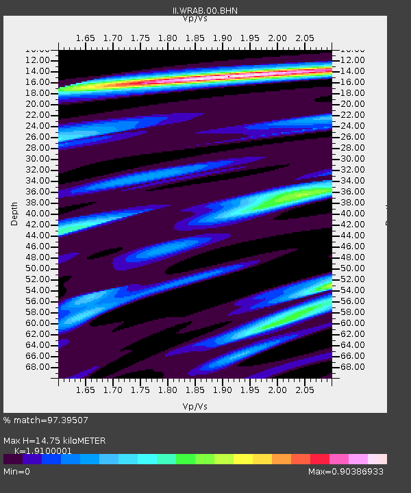
WRAB Tennant Creek, NT, Australia - Earthquake Result Viewer
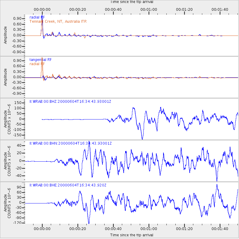
Earthquake location: Southern Sumatra, Indonesia
Earthquake latitude/longitude: -4.7/102.1
Earthquake time(UTC): 2000/06/04 (156) 16:28:26 GMT
Earthquake Depth: 33 km
Earthquake Magnitude: 6.8 MB, 8.0 MS, 7.9 MW, 7.7 MW
Earthquake Catalog/Contributor: WHDF/NEIC
Network: II Global Seismograph Network (GSN - IRIS/IDA)
Station: WRAB Tennant Creek, NT, Australia
Lat/Lon: 19.93 S/134.36 E
Elevation: 366 m
Distance: 34.9 deg
Az: 118.499 deg
Baz: 291.411 deg
Ray Param: 0.077462785
Estimated Moho Depth: 14.75 km
Estimated Crust Vp/Vs: 1.91
Assumed Crust Vp: 6.642 km/s
Estimated Crust Vs: 3.477 km/s
Estimated Crust Poisson's Ratio: 0.31
Radial Match: 97.39507 %
Radial Bump: 211
Transverse Match: 88.97728 %
Transverse Bump: 400
SOD ConfigId: 3744
Insert Time: 2010-03-01 23:23:23.131 +0000
GWidth: 2.5
Max Bumps: 400
Tol: 0.001

Signal To Noise

ChannelStoNSTALTA
II:WRAB:00:BHN:20000604T16:34:43.93001Z1.0863522.3403335E-72.1543049E-7
II:WRAB:00:BHE:20000604T16:34:43.920Z2.9366981.050526E-63.577235E-7
II:WRAB:00:BHZ:20000604T16:34:43.93001Z8.6112941.6101153E-61.8697718E-7
Arrivals
Ps2.2 SECOND
PpPs6.0 SECOND
PsPs/PpSs8.2 SECOND