You are here: Home > Network List > AV - Alaska Volcano Observatory Stations List
> Station AMKA Regional Station, Amchitka Island, Alaska > Earthquake Result Viewer
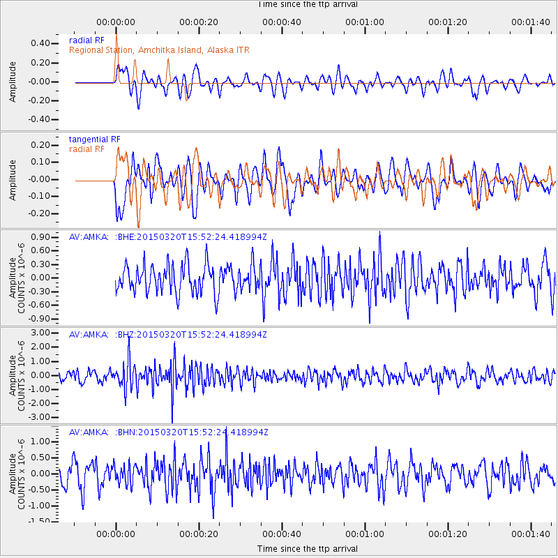
AMKA Regional Station, Amchitka Island, Alaska - Earthquake Result Viewer
*The percent match for this event was below the threshold and hence no stack was calculated.
| Earthquake location: |
Solomon Islands |
| Earthquake latitude/longitude: |
-4.8/154.8 |
| Earthquake time(UTC): |
2015/03/20 (079) 15:42:52 GMT |
| Earthquake Depth: |
26 km |
| Earthquake Magnitude: |
5.5 MWB |
| Earthquake Catalog/Contributor: |
NEIC PDE/NEIC COMCAT |
|
| Network: |
AV Alaska Volcano Observatory |
| Station: |
AMKA Regional Station, Amchitka Island, Alaska |
| Lat/Lon: |
51.38 N/179.30 E |
| Elevation: |
116 m |
|
| Distance: |
59.7 deg |
| Az: |
17.49 deg |
| Baz: |
208.547 deg |
| Ray Param: |
$rayparam |
*The percent match for this event was below the threshold and hence was not used in the summary stack. |
|
| Radial Match: |
43.003586 % |
| Radial Bump: |
400 |
| Transverse Match: |
45.66883 % |
| Transverse Bump: |
400 |
| SOD ConfigId: |
7422571 |
| Insert Time: |
2019-04-17 20:26:25.826 +0000 |
| GWidth: |
2.5 |
| Max Bumps: |
400 |
| Tol: |
0.001 |
|
Signal To Noise
| Channel | StoN | STA | LTA |
| AV:AMKA: :BHZ:20150320T15:52:24.418994Z | 3.2991612 | 9.299874E-7 | 2.8188603E-7 |
| AV:AMKA: :BHN:20150320T15:52:24.418994Z | 0.77909994 | 2.9944502E-7 | 3.8434737E-7 |
| AV:AMKA: :BHE:20150320T15:52:24.418994Z | 0.88191575 | 2.6824878E-7 | 3.04166E-7 |
| Arrivals |
| Ps | |
| PpPs | |
| PsPs/PpSs | |


