You are here: Home > Network List > NE - New England Seismic Network Stations List
> Station WVL Waterville, ME, USA > Earthquake Result Viewer
WVL Waterville, ME, USA - Earthquake Result Viewer
| Earthquake location: |
Rat Islands, Aleutian Islands |
| Earthquake latitude/longitude: |
51.8/178.8 |
| Earthquake time(UTC): |
2014/06/23 (174) 20:53:09 GMT |
| Earthquake Depth: |
108 km |
| Earthquake Magnitude: |
7.9 MWW, 7.1 MI, 7.9 MWC |
| Earthquake Catalog/Contributor: |
NEIC PDE/NEIC COMCAT |
|
| Network: |
NE New England Seismic Network |
| Station: |
WVL Waterville, ME, USA |
| Lat/Lon: |
44.56 N/69.66 W |
| Elevation: |
50 m |
|
| Distance: |
67.4 deg |
| Az: |
46.07 deg |
| Baz: |
321.267 deg |
| Ray Param: |
0.05672523 |
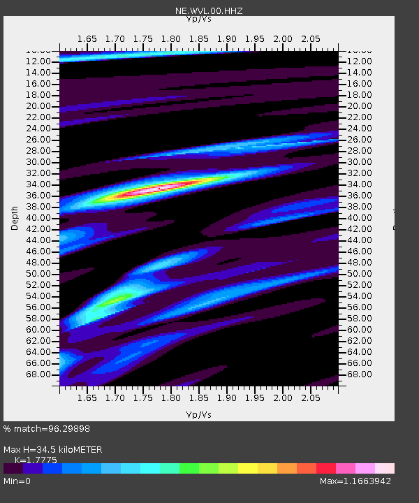
| Estimated Moho Depth: |
34.5 km |
| Estimated Crust Vp/Vs: |
1.78 |
| Assumed Crust Vp: |
6.419 km/s |
| Estimated Crust Vs: |
3.611 km/s |
| Estimated Crust Poisson's Ratio: |
0.27 |
|
| Radial Match: |
96.29898 % |
| Radial Bump: |
352 |
| Transverse Match: |
79.03785 % |
| Transverse Bump: |
400 |
| SOD ConfigId: |
739768 |
| Insert Time: |
2014-07-07 21:30:18.384 +0000 |
| GWidth: |
2.5 |
| Max Bumps: |
400 |
| Tol: |
0.001 |
|

Signal To Noise
| Channel | StoN | STA | LTA |
| NE:WVL:00:HHZ:20140623T21:03:22.813984Z | 2.16696 | 5.354197E-6 | 2.4708334E-6 |
| NE:WVL:00:HH1:20140623T21:03:22.813984Z | 4.027859 | 2.5086495E-6 | 6.2282453E-7 |
| NE:WVL:00:HH2:20140623T21:03:22.813984Z | 1.8118615 | 1.7401562E-6 | 9.604246E-7 |
| Arrivals |
| Ps | 4.3 SECOND |
| PpPs | 14 SECOND |
| PsPs/PpSs | 19 SECOND |


