You are here: Home > Network List > NI - North-East Italy Broadband Network Stations List
> Station ZOU2 Zouf Plan > Earthquake Result Viewer
ZOU2 Zouf Plan - Earthquake Result Viewer
| Earthquake location: |
Rat Islands, Aleutian Islands |
| Earthquake latitude/longitude: |
51.8/178.8 |
| Earthquake time(UTC): |
2014/06/23 (174) 20:53:09 GMT |
| Earthquake Depth: |
108 km |
| Earthquake Magnitude: |
7.9 MWW, 7.1 MI, 7.9 MWC |
| Earthquake Catalog/Contributor: |
NEIC PDE/NEIC COMCAT |
|
| Network: |
NI North-East Italy Broadband Network |
| Station: |
ZOU2 Zouf Plan |
| Lat/Lon: |
46.56 N/12.97 E |
| Elevation: |
1896 m |
|
| Distance: |
81.3 deg |
| Az: |
350.13 deg |
| Baz: |
8.874 deg |
| Ray Param: |
0.047465015 |
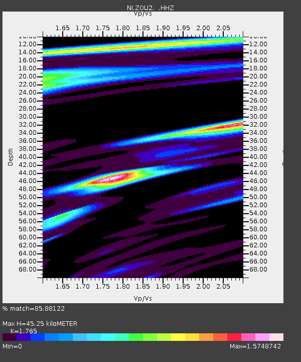
| Estimated Moho Depth: |
45.25 km |
| Estimated Crust Vp/Vs: |
1.76 |
| Assumed Crust Vp: |
6.35 km/s |
| Estimated Crust Vs: |
3.598 km/s |
| Estimated Crust Poisson's Ratio: |
0.26 |
|
| Radial Match: |
85.88122 % |
| Radial Bump: |
400 |
| Transverse Match: |
76.95634 % |
| Transverse Bump: |
399 |
| SOD ConfigId: |
739768 |
| Insert Time: |
2014-07-07 21:30:40.178 +0000 |
| GWidth: |
2.5 |
| Max Bumps: |
400 |
| Tol: |
0.001 |
|

Signal To Noise
| Channel | StoN | STA | LTA |
| NI:ZOU2: :HHZ:20140623T21:04:43.13802Z | 3.319016 | 6.8049862E-6 | 2.0503023E-6 |
| NI:ZOU2: :HHN:20140623T21:04:43.13802Z | 1.2349131 | 2.8966278E-6 | 2.3456128E-6 |
| NI:ZOU2: :HHE:20140623T21:04:43.13802Z | 2.1217268 | 5.321393E-6 | 2.508048E-6 |
| Arrivals |
| Ps | 5.6 SECOND |
| PpPs | 19 SECOND |
| PsPs/PpSs | 25 SECOND |


