You are here: Home > Network List > OK - Oklahoma Seismic Network Stations List
> Station FNO Franklin, Norman, OK > Earthquake Result Viewer
FNO Franklin, Norman, OK - Earthquake Result Viewer
| Earthquake location: |
Rat Islands, Aleutian Islands |
| Earthquake latitude/longitude: |
51.8/178.8 |
| Earthquake time(UTC): |
2014/06/23 (174) 20:53:09 GMT |
| Earthquake Depth: |
108 km |
| Earthquake Magnitude: |
7.9 MWW, 7.1 MI, 7.9 MWC |
| Earthquake Catalog/Contributor: |
NEIC PDE/NEIC COMCAT |
|
| Network: |
OK Oklahoma Seismic Network |
| Station: |
FNO Franklin, Norman, OK |
| Lat/Lon: |
35.26 N/97.40 W |
| Elevation: |
360 m |
|
| Distance: |
59.7 deg |
| Az: |
70.507 deg |
| Baz: |
314.33 deg |
| Ray Param: |
0.06172386 |
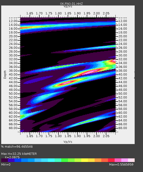
| Estimated Moho Depth: |
32.25 km |
| Estimated Crust Vp/Vs: |
2.10 |
| Assumed Crust Vp: |
6.426 km/s |
| Estimated Crust Vs: |
3.064 km/s |
| Estimated Crust Poisson's Ratio: |
0.35 |
|
| Radial Match: |
96.465546 % |
| Radial Bump: |
340 |
| Transverse Match: |
81.04174 % |
| Transverse Bump: |
400 |
| SOD ConfigId: |
739768 |
| Insert Time: |
2014-07-07 21:34:46.355 +0000 |
| GWidth: |
2.5 |
| Max Bumps: |
400 |
| Tol: |
0.001 |
|

Signal To Noise
| Channel | StoN | STA | LTA |
| OK:FNO:01:HHZ:20140623T21:02:32.318989Z | 1.344066 | 8.37383E-6 | 6.230222E-6 |
| OK:FNO:01:HHN:20140623T21:02:32.318989Z | 1.2013965 | 2.4169615E-6 | 2.0117932E-6 |
| OK:FNO:01:HHE:20140623T21:02:32.318989Z | 1.6983793 | 5.778359E-6 | 3.4022783E-6 |
| Arrivals |
| Ps | 5.7 SECOND |
| PpPs | 15 SECOND |
| PsPs/PpSs | 21 SECOND |


