You are here: Home > Network List > II - Global Seismograph Network (GSN - IRIS/IDA) Stations List
> Station WRAB Tennant Creek, NT, Australia > Earthquake Result Viewer
WRAB Tennant Creek, NT, Australia - Earthquake Result Viewer
| Earthquake location: |
Kuril Islands |
| Earthquake latitude/longitude: |
43.0/146.8 |
| Earthquake time(UTC): |
2000/01/28 (028) 14:21:07 GMT |
| Earthquake Depth: |
61 km |
| Earthquake Magnitude: |
6.7 MB, 6.6 MS, 6.8 MW, 6.8 ME |
| Earthquake Catalog/Contributor: |
WHDF/NEIC |
|
| Network: |
II Global Seismograph Network (GSN - IRIS/IDA) |
| Station: |
WRAB Tennant Creek, NT, Australia |
| Lat/Lon: |
19.93 S/134.36 E |
| Elevation: |
366 m |
|
| Distance: |
63.7 deg |
| Az: |
193.104 deg |
| Baz: |
10.175 deg |
| Ray Param: |
0.05925493 |
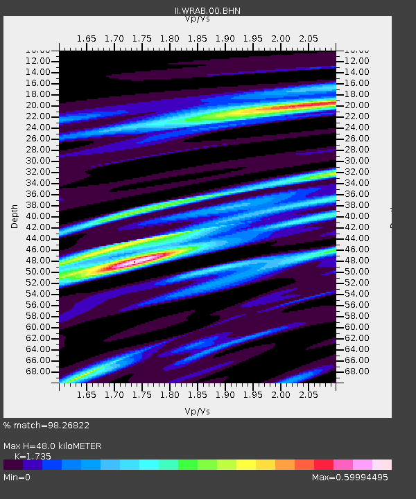
| Estimated Moho Depth: |
48.0 km |
| Estimated Crust Vp/Vs: |
1.74 |
| Assumed Crust Vp: |
6.642 km/s |
| Estimated Crust Vs: |
3.828 km/s |
| Estimated Crust Poisson's Ratio: |
0.25 |
|
| Radial Match: |
98.26822 % |
| Radial Bump: |
327 |
| Transverse Match: |
91.047554 % |
| Transverse Bump: |
400 |
| SOD ConfigId: |
3744 |
| Insert Time: |
2010-03-01 23:24:18.264 +0000 |
| GWidth: |
2.5 |
| Max Bumps: |
400 |
| Tol: |
0.001 |
|
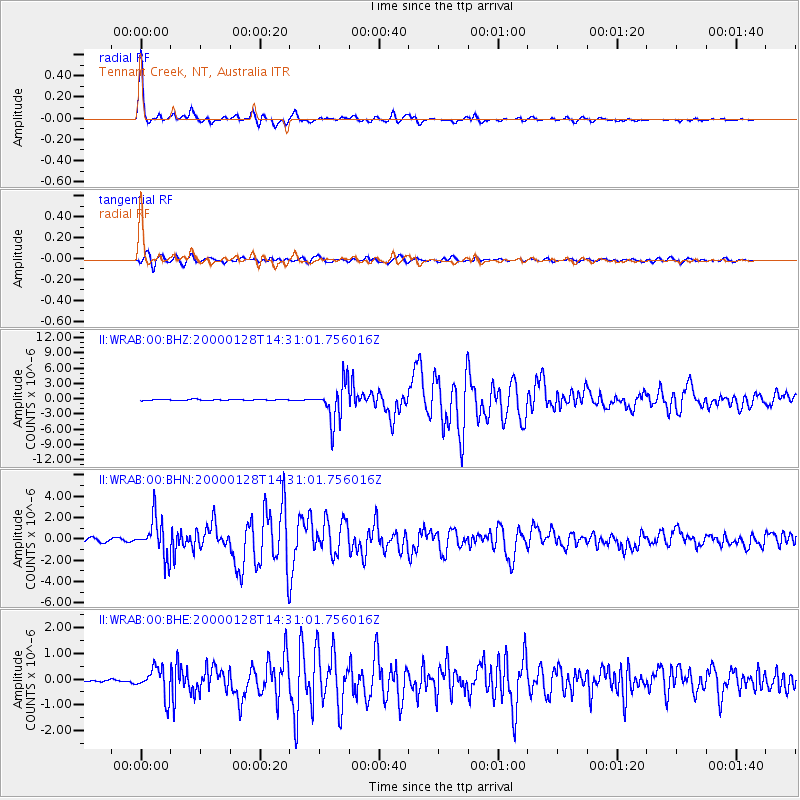
Signal To Noise
| Channel | StoN | STA | LTA |
| II:WRAB:00:BHN:20000128T14:31:01.756016Z | 9.989445 | 1.8206536E-6 | 1.8225774E-7 |
| II:WRAB:00:BHE:20000128T14:31:01.756016Z | 5.0644937 | 5.592606E-7 | 1.1042775E-7 |
| II:WRAB:00:BHZ:20000128T14:31:01.756016Z | 35.13373 | 3.8038713E-6 | 1.0826836E-7 |
| Arrivals |
| Ps | 5.6 SECOND |
| PpPs | 19 SECOND |
| PsPs/PpSs | 24 SECOND |


