You are here: Home > Network List > S - Seismographs in Schools Projects Stations List
> Station AURMK Renmark High School, SA > Earthquake Result Viewer
AURMK Renmark High School, SA - Earthquake Result Viewer
| Earthquake location: |
Rat Islands, Aleutian Islands |
| Earthquake latitude/longitude: |
51.8/178.8 |
| Earthquake time(UTC): |
2014/06/23 (174) 20:53:09 GMT |
| Earthquake Depth: |
108 km |
| Earthquake Magnitude: |
7.9 MWW, 7.1 MI, 7.9 MWC |
| Earthquake Catalog/Contributor: |
NEIC PDE/NEIC COMCAT |
|
| Network: |
S Seismographs in Schools Projects |
| Station: |
AURMK Renmark High School, SA |
| Lat/Lon: |
34.17 S/140.74 E |
| Elevation: |
26 m |
|
| Distance: |
91.9 deg |
| Az: |
210.727 deg |
| Baz: |
22.501 deg |
| Ray Param: |
0.041499402 |
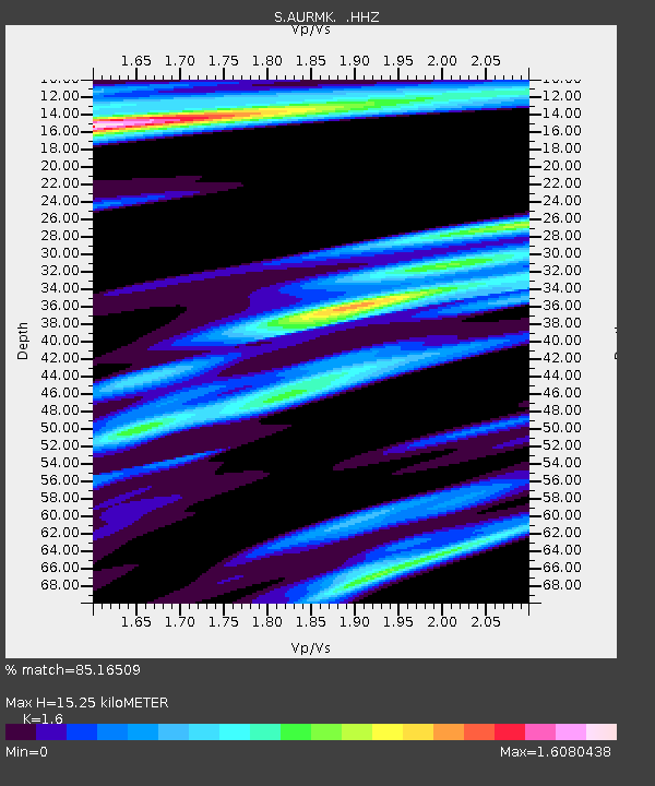
| Estimated Moho Depth: |
15.25 km |
| Estimated Crust Vp/Vs: |
1.60 |
| Assumed Crust Vp: |
6.418 km/s |
| Estimated Crust Vs: |
4.011 km/s |
| Estimated Crust Poisson's Ratio: |
0.18 |
|
| Radial Match: |
85.16509 % |
| Radial Bump: |
312 |
| Transverse Match: |
75.9164 % |
| Transverse Bump: |
372 |
| SOD ConfigId: |
739768 |
| Insert Time: |
2014-07-07 21:40:32.294 +0000 |
| GWidth: |
2.5 |
| Max Bumps: |
400 |
| Tol: |
0.001 |
|

Signal To Noise
| Channel | StoN | STA | LTA |
| S:AURMK: :HHZ:20140623T21:05:34.800007Z | 2.914682 | 1.3828341E-5 | 4.744374E-6 |
| S:AURMK: :HHN:20140623T21:05:34.800007Z | 0.9570329 | 1.2340093E-5 | 1.2894116E-5 |
| S:AURMK: :HHE:20140623T21:05:34.800007Z | 0.94047433 | 1.4720771E-5 | 1.5652497E-5 |
| Arrivals |
| Ps | 1.5 SECOND |
| PpPs | 6.0 SECOND |
| PsPs/PpSs | 7.5 SECOND |


