You are here: Home > Network List > UW - Pacific Northwest Regional Seismic Network Stations List
> Station LEBA Lebam, WA, USA > Earthquake Result Viewer
LEBA Lebam, WA, USA - Earthquake Result Viewer
*The percent match for this event was below the threshold and hence no stack was calculated.
| Earthquake location: |
Solomon Islands |
| Earthquake latitude/longitude: |
-4.8/154.8 |
| Earthquake time(UTC): |
2015/03/20 (079) 15:42:52 GMT |
| Earthquake Depth: |
26 km |
| Earthquake Magnitude: |
5.5 MWB |
| Earthquake Catalog/Contributor: |
NEIC PDE/NEIC COMCAT |
|
| Network: |
UW Pacific Northwest Regional Seismic Network |
| Station: |
LEBA Lebam, WA, USA |
| Lat/Lon: |
46.55 N/123.56 W |
| Elevation: |
73 m |
|
| Distance: |
87.7 deg |
| Az: |
43.107 deg |
| Baz: |
260.646 deg |
| Ray Param: |
$rayparam |
*The percent match for this event was below the threshold and hence was not used in the summary stack. |
|
| Radial Match: |
45.084885 % |
| Radial Bump: |
400 |
| Transverse Match: |
48.280643 % |
| Transverse Bump: |
400 |
| SOD ConfigId: |
7422571 |
| Insert Time: |
2019-04-17 20:30:13.493 +0000 |
| GWidth: |
2.5 |
| Max Bumps: |
400 |
| Tol: |
0.001 |
|
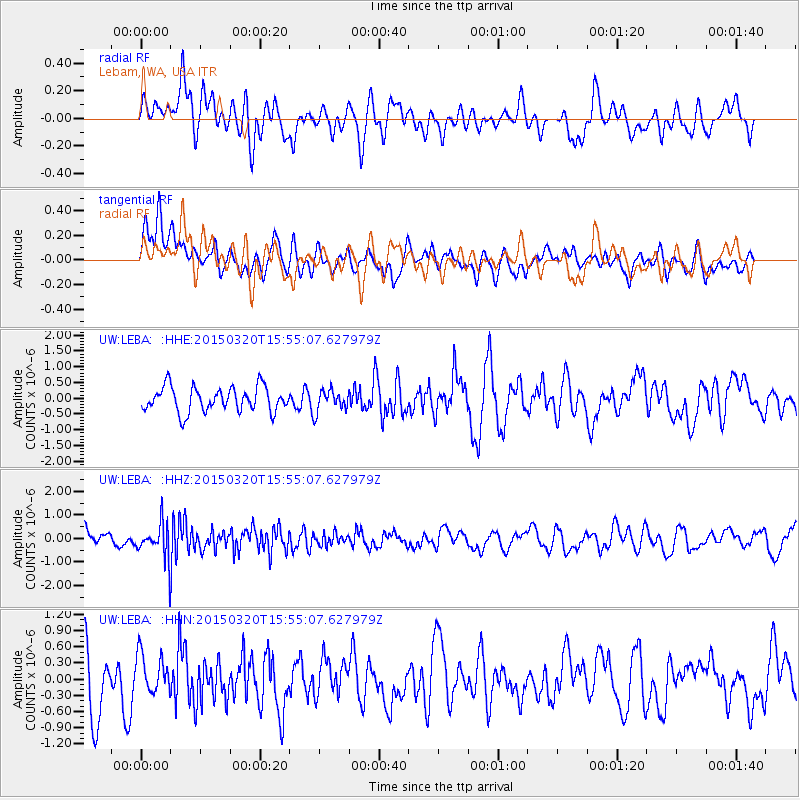
Signal To Noise
| Channel | StoN | STA | LTA |
| UW:LEBA: :HHZ:20150320T15:55:07.627979Z | 2.6053762 | 7.8507287E-7 | 3.0132801E-7 |
| UW:LEBA: :HHN:20150320T15:55:07.627979Z | 0.72512627 | 3.747706E-7 | 5.16835E-7 |
| UW:LEBA: :HHE:20150320T15:55:07.627979Z | 0.90453446 | 3.5802503E-7 | 3.9581136E-7 |
| Arrivals |
| Ps | |
| PpPs | |
| PsPs/PpSs | |


