You are here: Home > Network List > TA - USArray Transportable Network (new EarthScope stations) Stations List
> Station G54A Lake Saint Peter, ON, CAN > Earthquake Result Viewer
G54A Lake Saint Peter, ON, CAN - Earthquake Result Viewer
| Earthquake location: |
Rat Islands, Aleutian Islands |
| Earthquake latitude/longitude: |
51.8/178.8 |
| Earthquake time(UTC): |
2014/06/23 (174) 20:53:09 GMT |
| Earthquake Depth: |
108 km |
| Earthquake Magnitude: |
7.9 MWW, 7.1 MI, 7.9 MWC |
| Earthquake Catalog/Contributor: |
NEIC PDE/NEIC COMCAT |
|
| Network: |
TA USArray Transportable Network (new EarthScope stations) |
| Station: |
G54A Lake Saint Peter, ON, CAN |
| Lat/Lon: |
45.40 N/78.09 W |
| Elevation: |
465 m |
|
| Distance: |
62.8 deg |
| Az: |
50.462 deg |
| Baz: |
317.176 deg |
| Ray Param: |
0.059676696 |
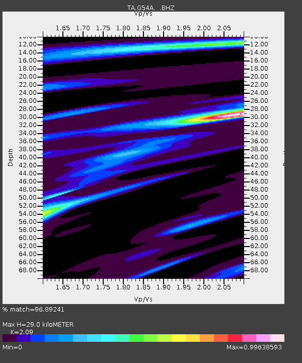
| Estimated Moho Depth: |
29.0 km |
| Estimated Crust Vp/Vs: |
2.09 |
| Assumed Crust Vp: |
6.577 km/s |
| Estimated Crust Vs: |
3.147 km/s |
| Estimated Crust Poisson's Ratio: |
0.35 |
|
| Radial Match: |
96.89241 % |
| Radial Bump: |
286 |
| Transverse Match: |
81.07171 % |
| Transverse Bump: |
400 |
| SOD ConfigId: |
739768 |
| Insert Time: |
2014-07-07 21:46:13.375 +0000 |
| GWidth: |
2.5 |
| Max Bumps: |
400 |
| Tol: |
0.001 |
|

Signal To Noise
| Channel | StoN | STA | LTA |
| TA:G54A: :BHZ:20140623T21:02:53.54897Z | 3.0360553 | 7.3937977E-6 | 2.4353303E-6 |
| TA:G54A: :BHN:20140623T21:02:53.54897Z | 3.8372567 | 3.055953E-6 | 7.9639E-7 |
| TA:G54A: :BHE:20140623T21:02:53.54897Z | 1.9276395 | 3.1396487E-6 | 1.628753E-6 |
| Arrivals |
| Ps | 5.0 SECOND |
| PpPs | 13 SECOND |
| PsPs/PpSs | 18 SECOND |


