You are here: Home > Network List > TA - USArray Transportable Network (new EarthScope stations) Stations List
> Station H52A Wyevale, ON, CAN > Earthquake Result Viewer
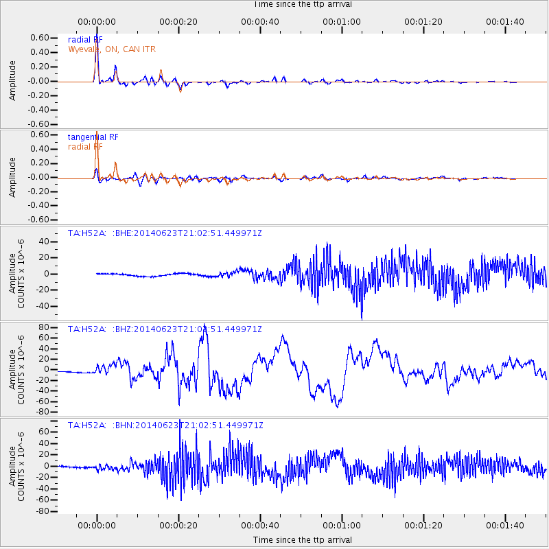
H52A Wyevale, ON, CAN - Earthquake Result Viewer

| Earthquake location: |
Rat Islands, Aleutian Islands |
| Earthquake latitude/longitude: |
51.8/178.8 |
| Earthquake time(UTC): |
2014/06/23 (174) 20:53:09 GMT |
| Earthquake Depth: |
108 km |
| Earthquake Magnitude: |
7.9 MWW, 7.1 MI, 7.9 MWC |
| Earthquake Catalog/Contributor: |
NEIC PDE/NEIC COMCAT |
|
| Network: |
TA USArray Transportable Network (new EarthScope stations) |
| Station: |
H52A Wyevale, ON, CAN |
| Lat/Lon: |
44.64 N/79.89 W |
| Elevation: |
209 m |
|
| Distance: |
62.5 deg |
| Az: |
52.092 deg |
| Baz: |
316.656 deg |
| Ray Param: |
0.05988239 |
| Estimated Moho Depth: |
39.75 km |
| Estimated Crust Vp/Vs: |
1.74 |
| Assumed Crust Vp: |
6.577 km/s |
| Estimated Crust Vs: |
3.774 km/s |
| Estimated Crust Poisson's Ratio: |
0.25 |
|
| Radial Match: |
97.3319 % |
| Radial Bump: |
299 |
| Transverse Match: |
80.97728 % |
| Transverse Bump: |
400 |
| SOD ConfigId: |
739768 |
| Insert Time: |
2014-07-07 21:47:16.443 +0000 |
| GWidth: |
2.5 |
| Max Bumps: |
400 |
| Tol: |
0.001 |
|
Signal To Noise
| Channel | StoN | STA | LTA |
| TA:H52A: :BHZ:20140623T21:02:51.449971Z | 4.969337 | 8.687419E-6 | 1.7482048E-6 |
| TA:H52A: :BHN:20140623T21:02:51.449971Z | 2.9852898 | 3.6539266E-6 | 1.2239772E-6 |
| TA:H52A: :BHE:20140623T21:02:51.449971Z | 1.9504434 | 2.8959537E-6 | 1.4847669E-6 |
| Arrivals |
| Ps | 4.7 SECOND |
| PpPs | 16 SECOND |
| PsPs/PpSs | 21 SECOND |


