You are here: Home > Network List > II - Global Seismograph Network (GSN - IRIS/IDA) Stations List
> Station WRAB Tennant Creek, NT, Australia > Earthquake Result Viewer
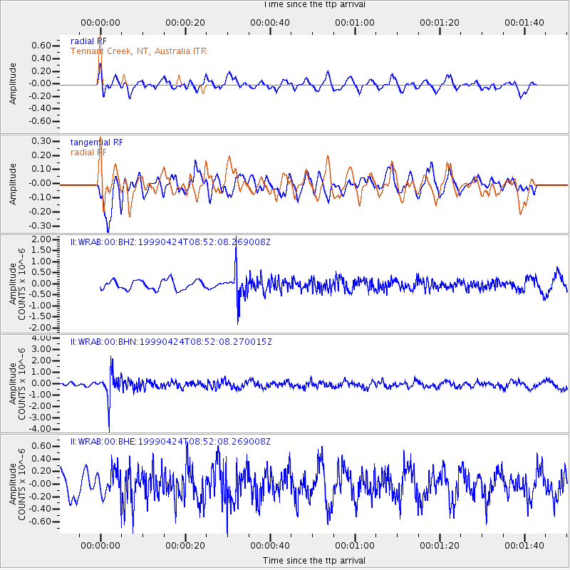
WRAB Tennant Creek, NT, Australia - Earthquake Result Viewer
*The percent match for this event was below the threshold and hence no stack was calculated.
| Earthquake location: |
Fiji Islands Region |
| Earthquake latitude/longitude: |
-18.0/-178.4 |
| Earthquake time(UTC): |
1999/04/24 (114) 08:45:16 GMT |
| Earthquake Depth: |
568 km |
| Earthquake Magnitude: |
5.6 MW, 5.2 MB, 5.5 MW |
| Earthquake Catalog/Contributor: |
WHDF/NEIC |
|
| Network: |
II Global Seismograph Network (GSN - IRIS/IDA) |
| Station: |
WRAB Tennant Creek, NT, Australia |
| Lat/Lon: |
19.93 S/134.36 E |
| Elevation: |
366 m |
|
| Distance: |
44.6 deg |
| Az: |
259.684 deg |
| Baz: |
95.768 deg |
| Ray Param: |
$rayparam |
*The percent match for this event was below the threshold and hence was not used in the summary stack. |
|
| Radial Match: |
49.725315 % |
| Radial Bump: |
400 |
| Transverse Match: |
59.11302 % |
| Transverse Bump: |
400 |
| SOD ConfigId: |
4480 |
| Insert Time: |
2010-03-01 23:24:56.342 +0000 |
| GWidth: |
2.5 |
| Max Bumps: |
400 |
| Tol: |
0.001 |
|
Signal To Noise
| Channel | StoN | STA | LTA |
| II:WRAB:00:BHN:19990424T08:52:08.270015Z | 6.666676 | 1.0989165E-6 | 1.6483725E-7 |
| II:WRAB:00:BHE:19990424T08:52:08.269008Z | 1.4055737 | 2.0601873E-7 | 1.4657269E-7 |
| II:WRAB:00:BHZ:19990424T08:52:08.269008Z | 3.0135252 | 6.23416E-7 | 2.0687267E-7 |
| Arrivals |
| Ps | |
| PpPs | |
| PsPs/PpSs | |


