You are here: Home > Network List > TA - USArray Transportable Network (new EarthScope stations) Stations List
> Station I59A Olmsteadville, NY, USA > Earthquake Result Viewer
I59A Olmsteadville, NY, USA - Earthquake Result Viewer

| Earthquake location: |
Rat Islands, Aleutian Islands |
| Earthquake latitude/longitude: |
51.8/178.8 |
| Earthquake time(UTC): |
2014/06/23 (174) 20:53:09 GMT |
| Earthquake Depth: |
108 km |
| Earthquake Magnitude: |
7.9 MWW, 7.1 MI, 7.9 MWC |
| Earthquake Catalog/Contributor: |
NEIC PDE/NEIC COMCAT |
|
| Network: |
TA USArray Transportable Network (new EarthScope stations) |
| Station: |
I59A Olmsteadville, NY, USA |
| Lat/Lon: |
43.80 N/73.87 W |
| Elevation: |
390 m |
|
| Distance: |
66.0 deg |
| Az: |
49.147 deg |
| Baz: |
319.558 deg |
| Ray Param: |
0.057601064 |
| Estimated Moho Depth: |
57.25 km |
| Estimated Crust Vp/Vs: |
1.60 |
| Assumed Crust Vp: |
6.419 km/s |
| Estimated Crust Vs: |
4.012 km/s |
| Estimated Crust Poisson's Ratio: |
0.18 |
|
| Radial Match: |
97.92779 % |
| Radial Bump: |
218 |
| Transverse Match: |
78.776794 % |
| Transverse Bump: |
400 |
| SOD ConfigId: |
739768 |
| Insert Time: |
2014-07-07 21:49:02.033 +0000 |
| GWidth: |
2.5 |
| Max Bumps: |
400 |
| Tol: |
0.001 |
|
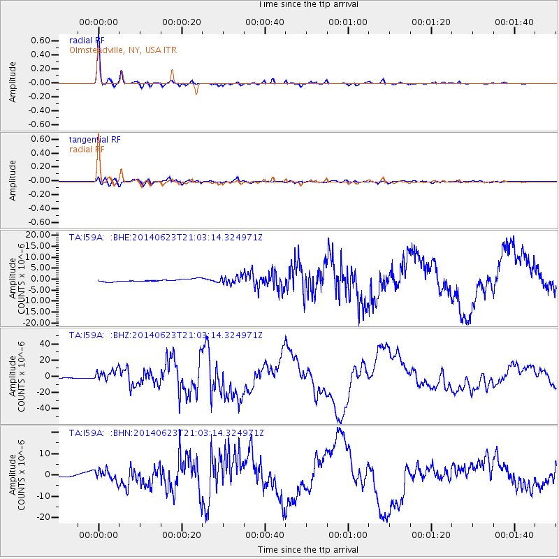
Signal To Noise
| Channel | StoN | STA | LTA |
| TA:I59A: :BHZ:20140623T21:03:14.324971Z | 3.415936 | 7.3829588E-6 | 2.1613282E-6 |
| TA:I59A: :BHN:20140623T21:03:14.324971Z | 7.4190993 | 2.567893E-6 | 3.4611924E-7 |
| TA:I59A: :BHE:20140623T21:03:14.324971Z | 3.0789587 | 1.6381567E-6 | 5.3204894E-7 |
| Arrivals |
| Ps | 5.6 SECOND |
| PpPs | 22 SECOND |
| PsPs/PpSs | 28 SECOND |


