You are here: Home > Network List > TA - USArray Transportable Network (new EarthScope stations) Stations List
> Station J58A Remsen, NY, USA > Earthquake Result Viewer
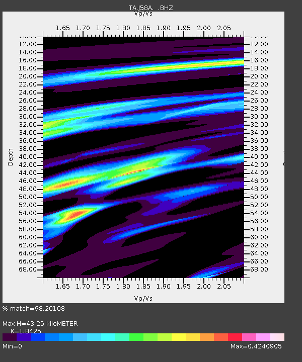
J58A Remsen, NY, USA - Earthquake Result Viewer
| Earthquake location: |
Rat Islands, Aleutian Islands |
| Earthquake latitude/longitude: |
51.8/178.8 |
| Earthquake time(UTC): |
2014/06/23 (174) 20:53:09 GMT |
| Earthquake Depth: |
108 km |
| Earthquake Magnitude: |
7.9 MWW, 7.1 MI, 7.9 MWC |
| Earthquake Catalog/Contributor: |
NEIC PDE/NEIC COMCAT |
|
| Network: |
TA USArray Transportable Network (new EarthScope stations) |
| Station: |
J58A Remsen, NY, USA |
| Lat/Lon: |
43.36 N/75.29 W |
| Elevation: |
436 m |
|
| Distance: |
65.7 deg |
| Az: |
50.31 deg |
| Baz: |
319.065 deg |
| Ray Param: |
0.057821084 |
| Estimated Moho Depth: |
43.25 km |
| Estimated Crust Vp/Vs: |
1.84 |
| Assumed Crust Vp: |
6.419 km/s |
| Estimated Crust Vs: |
3.484 km/s |
| Estimated Crust Poisson's Ratio: |
0.29 |
|
| Radial Match: |
98.20108 % |
| Radial Bump: |
281 |
| Transverse Match: |
83.77301 % |
| Transverse Bump: |
400 |
| SOD ConfigId: |
739768 |
| Insert Time: |
2014-07-07 21:50:04.730 +0000 |
| GWidth: |
2.5 |
| Max Bumps: |
400 |
| Tol: |
0.001 |
|

Signal To Noise
| Channel | StoN | STA | LTA |
| TA:J58A: :BHZ:20140623T21:03:12.175007Z | 2.9254057 | 6.66794E-6 | 2.2793215E-6 |
| TA:J58A: :BHN:20140623T21:03:12.175007Z | 1.9800984 | 2.2536617E-6 | 1.1381564E-6 |
| TA:J58A: :BHE:20140623T21:03:12.175007Z | 3.616234 | 2.372607E-6 | 6.560989E-7 |
| Arrivals |
| Ps | 5.9 SECOND |
| PpPs | 18 SECOND |
| PsPs/PpSs | 24 SECOND |


