You are here: Home > Network List > TA - USArray Transportable Network (new EarthScope stations) Stations List
> Station K50A Casco, MI, USA > Earthquake Result Viewer
K50A Casco, MI, USA - Earthquake Result Viewer
| Earthquake location: |
Rat Islands, Aleutian Islands |
| Earthquake latitude/longitude: |
51.8/178.8 |
| Earthquake time(UTC): |
2014/06/23 (174) 20:53:09 GMT |
| Earthquake Depth: |
108 km |
| Earthquake Magnitude: |
7.9 MWW, 7.1 MI, 7.9 MWC |
| Earthquake Catalog/Contributor: |
NEIC PDE/NEIC COMCAT |
|
| Network: |
TA USArray Transportable Network (new EarthScope stations) |
| Station: |
K50A Casco, MI, USA |
| Lat/Lon: |
42.77 N/82.62 W |
| Elevation: |
191 m |
|
| Distance: |
62.5 deg |
| Az: |
55.162 deg |
| Baz: |
316.191 deg |
| Ray Param: |
0.059891924 |
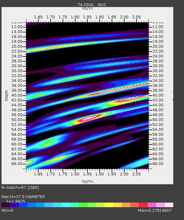
| Estimated Moho Depth: |
37.5 km |
| Estimated Crust Vp/Vs: |
1.96 |
| Assumed Crust Vp: |
6.483 km/s |
| Estimated Crust Vs: |
3.303 km/s |
| Estimated Crust Poisson's Ratio: |
0.32 |
|
| Radial Match: |
97.22681 % |
| Radial Bump: |
227 |
| Transverse Match: |
82.50933 % |
| Transverse Bump: |
400 |
| SOD ConfigId: |
739768 |
| Insert Time: |
2014-07-07 21:50:56.998 +0000 |
| GWidth: |
2.5 |
| Max Bumps: |
400 |
| Tol: |
0.001 |
|

Signal To Noise
| Channel | StoN | STA | LTA |
| TA:K50A: :BHZ:20140623T21:02:51.349995Z | 2.5731537 | 7.6148826E-6 | 2.959358E-6 |
| TA:K50A: :BHN:20140623T21:02:51.349995Z | 2.072895 | 2.1916408E-6 | 1.057285E-6 |
| TA:K50A: :BHE:20140623T21:02:51.349995Z | 1.2516502 | 3.2039995E-6 | 2.5598204E-6 |
| Arrivals |
| Ps | 5.8 SECOND |
| PpPs | 16 SECOND |
| PsPs/PpSs | 22 SECOND |


