You are here: Home > Network List > II - Global Seismograph Network (GSN - IRIS/IDA) Stations List
> Station WRAB Tennant Creek, NT, Australia > Earthquake Result Viewer
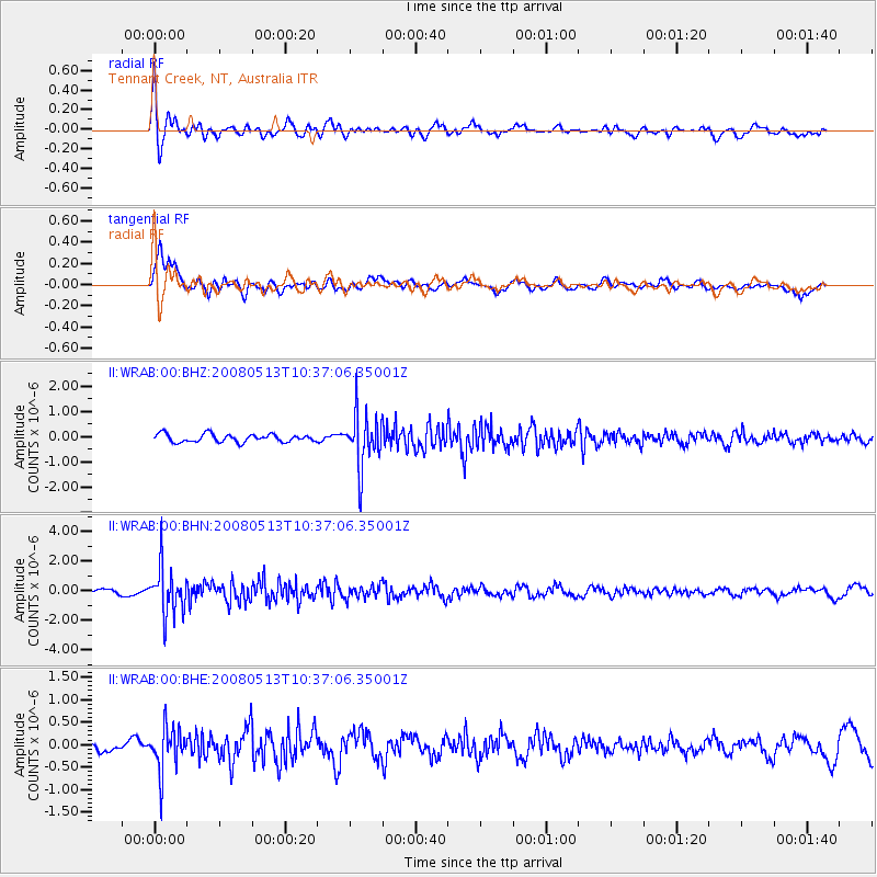
WRAB Tennant Creek, NT, Australia - Earthquake Result Viewer
*The percent match for this event was below the threshold and hence no stack was calculated.
| Earthquake location: |
Northern Sumatra, Indonesia |
| Earthquake latitude/longitude: |
4.7/95.1 |
| Earthquake time(UTC): |
2008/05/13 (134) 10:29:19 GMT |
| Earthquake Depth: |
35 km |
| Earthquake Magnitude: |
5.6 MB, 5.1 MS, 5.4 MW, 5.4 MW |
| Earthquake Catalog/Contributor: |
WHDF/NEIC |
|
| Network: |
II Global Seismograph Network (GSN - IRIS/IDA) |
| Station: |
WRAB Tennant Creek, NT, Australia |
| Lat/Lon: |
19.93 S/134.36 E |
| Elevation: |
366 m |
|
| Distance: |
45.7 deg |
| Az: |
123.674 deg |
| Baz: |
298.158 deg |
| Ray Param: |
$rayparam |
*The percent match for this event was below the threshold and hence was not used in the summary stack. |
|
| Radial Match: |
73.36767 % |
| Radial Bump: |
400 |
| Transverse Match: |
83.16426 % |
| Transverse Bump: |
400 |
| SOD ConfigId: |
2504 |
| Insert Time: |
2010-03-01 23:25:10.548 +0000 |
| GWidth: |
2.5 |
| Max Bumps: |
400 |
| Tol: |
0.001 |
|
Signal To Noise
| Channel | StoN | STA | LTA |
| II:WRAB:00:BHN:20080513T10:37:06.35001Z | 7.5828166 | 1.6340192E-6 | 2.1548975E-7 |
| II:WRAB:00:BHE:20080513T10:37:06.35001Z | 2.9039645 | 4.9958015E-7 | 1.7203384E-7 |
| II:WRAB:00:BHZ:20080513T10:37:06.35001Z | 6.9632587 | 1.0908051E-6 | 1.5665152E-7 |
| Arrivals |
| Ps | |
| PpPs | |
| PsPs/PpSs | |


