You are here: Home > Network List > II - Global Seismograph Network (GSN - IRIS/IDA) Stations List
> Station WRAB Tennant Creek, NT, Australia > Earthquake Result Viewer
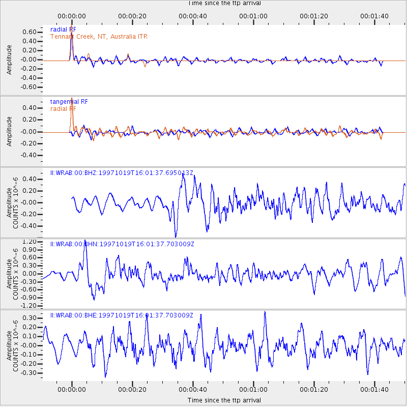
WRAB Tennant Creek, NT, Australia - Earthquake Result Viewer
*The percent match for this event was below the threshold and hence no stack was calculated.
| Earthquake location: |
Tonga Islands |
| Earthquake latitude/longitude: |
-21.8/-175.0 |
| Earthquake time(UTC): |
1997/10/19 (292) 15:53:38 GMT |
| Earthquake Depth: |
33 km |
| Earthquake Magnitude: |
5.6 MB, 5.9 MS |
| Earthquake Catalog/Contributor: |
WHDF/NEIC |
|
| Network: |
II Global Seismograph Network (GSN - IRIS/IDA) |
| Station: |
WRAB Tennant Creek, NT, Australia |
| Lat/Lon: |
19.93 S/134.36 E |
| Elevation: |
366 m |
|
| Distance: |
47.2 deg |
| Az: |
262.584 deg |
| Baz: |
101.601 deg |
| Ray Param: |
$rayparam |
*The percent match for this event was below the threshold and hence was not used in the summary stack. |
|
| Radial Match: |
68.04844 % |
| Radial Bump: |
327 |
| Transverse Match: |
55.379745 % |
| Transverse Bump: |
389 |
| SOD ConfigId: |
4480 |
| Insert Time: |
2010-03-01 23:25:15.622 +0000 |
| GWidth: |
2.5 |
| Max Bumps: |
400 |
| Tol: |
0.001 |
|
Signal To Noise
| Channel | StoN | STA | LTA |
| II:WRAB:00:BHN:19971019T16:01:37.703009Z | 4.459345 | 4.9886035E-7 | 1.1186852E-7 |
| II:WRAB:00:BHE:19971019T16:01:37.703009Z | 0.7892054 | 7.971501E-8 | 1.0100668E-7 |
| II:WRAB:00:BHZ:19971019T16:01:37.695013Z | 2.762753 | 2.3666816E-7 | 8.5663885E-8 |
| Arrivals |
| Ps | |
| PpPs | |
| PsPs/PpSs | |


