You are here: Home > Network List > TA - USArray Transportable Network (new EarthScope stations) Stations List
> Station M57A Sunshine Farm, Cogan Station, PA, USA > Earthquake Result Viewer
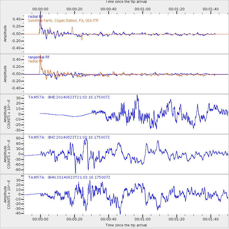
M57A Sunshine Farm, Cogan Station, PA, USA - Earthquake Result Viewer
| Earthquake location: |
Rat Islands, Aleutian Islands |
| Earthquake latitude/longitude: |
51.8/178.8 |
| Earthquake time(UTC): |
2014/06/23 (174) 20:53:09 GMT |
| Earthquake Depth: |
108 km |
| Earthquake Magnitude: |
7.9 MWW, 7.1 MI, 7.9 MWC |
| Earthquake Catalog/Contributor: |
NEIC PDE/NEIC COMCAT |
|
| Network: |
TA USArray Transportable Network (new EarthScope stations) |
| Station: |
M57A Sunshine Farm, Cogan Station, PA, USA |
| Lat/Lon: |
41.34 N/77.13 W |
| Elevation: |
319 m |
|
| Distance: |
66.3 deg |
| Az: |
52.89 deg |
| Baz: |
318.878 deg |
| Ray Param: |
0.05740943 |
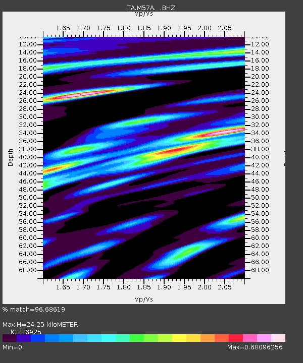
| Estimated Moho Depth: |
24.25 km |
| Estimated Crust Vp/Vs: |
1.69 |
| Assumed Crust Vp: |
6.121 km/s |
| Estimated Crust Vs: |
3.616 km/s |
| Estimated Crust Poisson's Ratio: |
0.23 |
|
| Radial Match: |
96.68619 % |
| Radial Bump: |
400 |
| Transverse Match: |
76.24699 % |
| Transverse Bump: |
400 |
| SOD ConfigId: |
739768 |
| Insert Time: |
2014-07-07 21:53:29.266 +0000 |
| GWidth: |
2.5 |
| Max Bumps: |
400 |
| Tol: |
0.001 |
|
Signal To Noise
| Channel | StoN | STA | LTA |
| TA:M57A: :BHZ:20140623T21:03:16.175007Z | 2.118515 | 9.715927E-6 | 4.586197E-6 |
| TA:M57A: :BHN:20140623T21:03:16.175007Z | 3.3577 | 2.370913E-6 | 7.061122E-7 |
| TA:M57A: :BHE:20140623T21:03:16.175007Z | 2.798371 | 5.2811442E-6 | 1.8872208E-6 |
| Arrivals |
| Ps | 2.9 SECOND |
| PpPs | 10 SECOND |
| PsPs/PpSs | 13 SECOND |


