You are here: Home > Network List > II - Global Seismograph Network (GSN - IRIS/IDA) Stations List
> Station WRAB Tennant Creek, NT, Australia > Earthquake Result Viewer
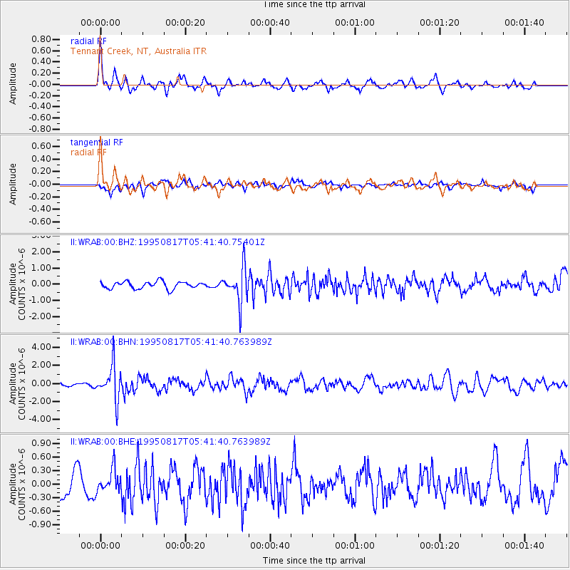
WRAB Tennant Creek, NT, Australia - Earthquake Result Viewer
*The percent match for this event was below the threshold and hence no stack was calculated.
| Earthquake location: |
Southeast Of Loyalty Islands |
| Earthquake latitude/longitude: |
-21.8/170.4 |
| Earthquake time(UTC): |
1995/08/17 (229) 05:35:37 GMT |
| Earthquake Depth: |
75 km |
| Earthquake Magnitude: |
5.5 MB, 6.1 UNKNOWN |
| Earthquake Catalog/Contributor: |
WHDF/NEIC |
|
| Network: |
II Global Seismograph Network (GSN - IRIS/IDA) |
| Station: |
WRAB Tennant Creek, NT, Australia |
| Lat/Lon: |
19.93 S/134.36 E |
| Elevation: |
366 m |
|
| Distance: |
33.7 deg |
| Az: |
266.514 deg |
| Baz: |
99.661 deg |
| Ray Param: |
$rayparam |
*The percent match for this event was below the threshold and hence was not used in the summary stack. |
|
| Radial Match: |
77.22376 % |
| Radial Bump: |
400 |
| Transverse Match: |
72.00209 % |
| Transverse Bump: |
380 |
| SOD ConfigId: |
4480 |
| Insert Time: |
2010-03-01 23:25:25.478 +0000 |
| GWidth: |
2.5 |
| Max Bumps: |
400 |
| Tol: |
0.001 |
|
Signal To Noise
| Channel | StoN | STA | LTA |
| II:WRAB:00:BHN:19950817T05:41:40.763989Z | 7.2328906 | 1.9532117E-6 | 2.700458E-7 |
| II:WRAB:00:BHE:19950817T05:41:40.763989Z | 0.9588462 | 2.511407E-7 | 2.619197E-7 |
| II:WRAB:00:BHZ:19950817T05:41:40.75401Z | 5.0017776 | 1.0931941E-6 | 2.1856111E-7 |
| Arrivals |
| Ps | |
| PpPs | |
| PsPs/PpSs | |


