You are here: Home > Network List > TA - USArray Transportable Network (new EarthScope stations) Stations List
> Station MDND Maddock, ND, USA > Earthquake Result Viewer
MDND Maddock, ND, USA - Earthquake Result Viewer
| Earthquake location: |
Rat Islands, Aleutian Islands |
| Earthquake latitude/longitude: |
51.8/178.8 |
| Earthquake time(UTC): |
2014/06/23 (174) 20:53:09 GMT |
| Earthquake Depth: |
108 km |
| Earthquake Magnitude: |
7.9 MWW, 7.1 MI, 7.9 MWC |
| Earthquake Catalog/Contributor: |
NEIC PDE/NEIC COMCAT |
|
| Network: |
TA USArray Transportable Network (new EarthScope stations) |
| Station: |
MDND Maddock, ND, USA |
| Lat/Lon: |
47.85 N/99.60 W |
| Elevation: |
479 m |
|
| Distance: |
50.2 deg |
| Az: |
60.164 deg |
| Baz: |
306.893 deg |
| Ray Param: |
0.06785435 |
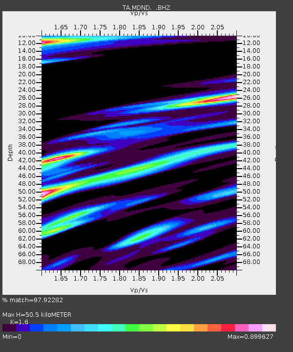
| Estimated Moho Depth: |
50.5 km |
| Estimated Crust Vp/Vs: |
1.60 |
| Assumed Crust Vp: |
6.53 km/s |
| Estimated Crust Vs: |
4.082 km/s |
| Estimated Crust Poisson's Ratio: |
0.18 |
|
| Radial Match: |
97.92282 % |
| Radial Bump: |
371 |
| Transverse Match: |
89.20073 % |
| Transverse Bump: |
400 |
| SOD ConfigId: |
739768 |
| Insert Time: |
2014-07-07 21:54:07.268 +0000 |
| GWidth: |
2.5 |
| Max Bumps: |
400 |
| Tol: |
0.001 |
|
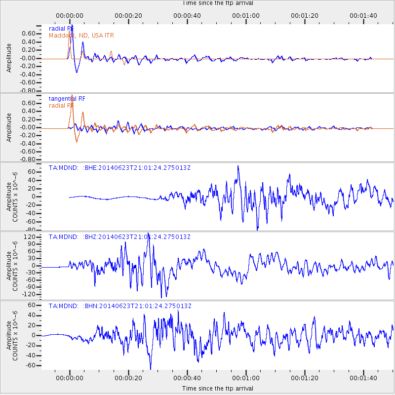
Signal To Noise
| Channel | StoN | STA | LTA |
| TA:MDND: :BHZ:20140623T21:01:24.275013Z | 6.9377317 | 1.0096202E-5 | 1.4552596E-6 |
| TA:MDND: :BHN:20140623T21:01:24.275013Z | 3.5888066 | 4.4665408E-6 | 1.2445755E-6 |
| TA:MDND: :BHE:20140623T21:01:24.275013Z | 2.0256095 | 4.922421E-6 | 2.4300937E-6 |
| Arrivals |
| Ps | 5.0 SECOND |
| PpPs | 19 SECOND |
| PsPs/PpSs | 24 SECOND |


