You are here: Home > Network List > TA - USArray Transportable Network (new EarthScope stations) Stations List
> Station N02D Trinity Center, CA, USA > Earthquake Result Viewer
N02D Trinity Center, CA, USA - Earthquake Result Viewer

| Earthquake location: |
Rat Islands, Aleutian Islands |
| Earthquake latitude/longitude: |
51.8/178.8 |
| Earthquake time(UTC): |
2014/06/23 (174) 20:53:09 GMT |
| Earthquake Depth: |
108 km |
| Earthquake Magnitude: |
7.9 MWW, 7.1 MI, 7.9 MWC |
| Earthquake Catalog/Contributor: |
NEIC PDE/NEIC COMCAT |
|
| Network: |
TA USArray Transportable Network (new EarthScope stations) |
| Station: |
N02D Trinity Center, CA, USA |
| Lat/Lon: |
40.97 N/122.71 W |
| Elevation: |
937 m |
|
| Distance: |
40.8 deg |
| Az: |
81.558 deg |
| Baz: |
305.78 deg |
| Ray Param: |
0.07383183 |
| Estimated Moho Depth: |
25.75 km |
| Estimated Crust Vp/Vs: |
1.68 |
| Assumed Crust Vp: |
6.566 km/s |
| Estimated Crust Vs: |
3.914 km/s |
| Estimated Crust Poisson's Ratio: |
0.22 |
|
| Radial Match: |
95.68139 % |
| Radial Bump: |
377 |
| Transverse Match: |
90.06091 % |
| Transverse Bump: |
400 |
| SOD ConfigId: |
739768 |
| Insert Time: |
2014-07-07 21:54:15.778 +0000 |
| GWidth: |
2.5 |
| Max Bumps: |
400 |
| Tol: |
0.001 |
|
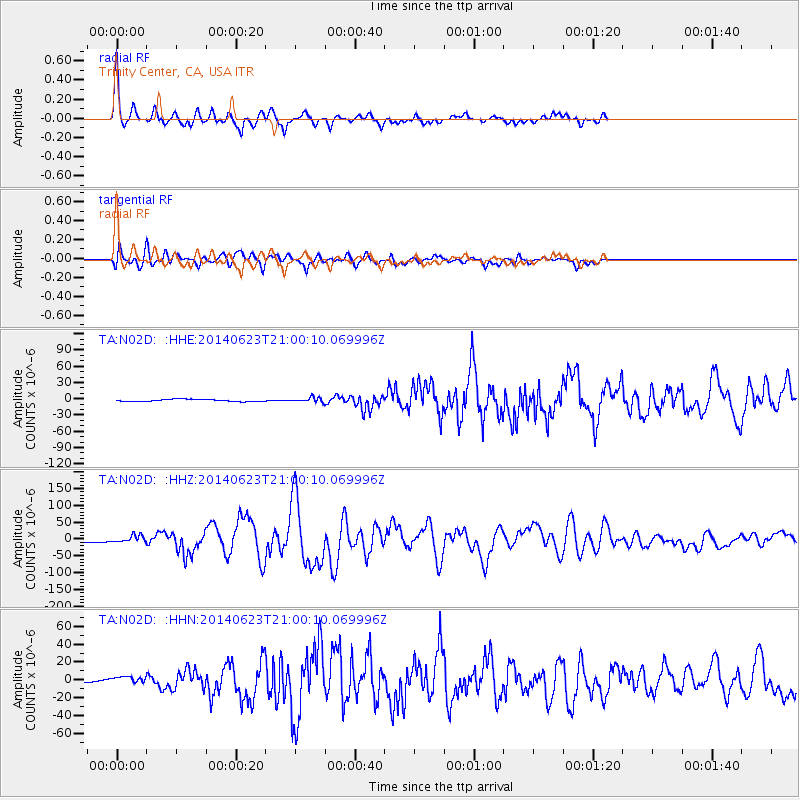
Signal To Noise
| Channel | StoN | STA | LTA |
| TA:N02D: :HHZ:20140623T21:00:10.069996Z | 2.275487 | 1.0183624E-5 | 4.47536E-6 |
| TA:N02D: :HHN:20140623T21:00:10.069996Z | 1.5069585 | 3.4936204E-6 | 2.3183254E-6 |
| TA:N02D: :HHE:20140623T21:00:10.069996Z | 2.1045544 | 4.2719757E-6 | 2.029872E-6 |
| Arrivals |
| Ps | 2.9 SECOND |
| PpPs | 9.7 SECOND |
| PsPs/PpSs | 13 SECOND |


