You are here: Home > Network List > II - Global Seismograph Network (GSN - IRIS/IDA) Stations List
> Station WRAB Tennant Creek, NT, Australia > Earthquake Result Viewer
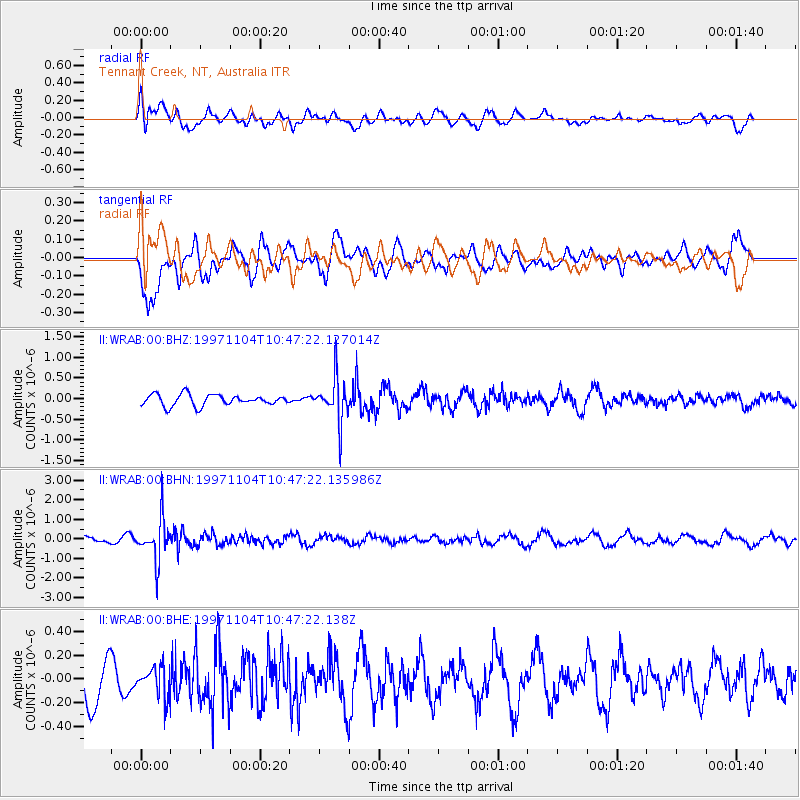
WRAB Tennant Creek, NT, Australia - Earthquake Result Viewer
*The percent match for this event was below the threshold and hence no stack was calculated.
| Earthquake location: |
Fiji Islands Region |
| Earthquake latitude/longitude: |
-21.0/-179.2 |
| Earthquake time(UTC): |
1997/11/04 (308) 10:40:43 GMT |
| Earthquake Depth: |
621 km |
| Earthquake Magnitude: |
5.7 UNKNOWN, 5.1 MB |
| Earthquake Catalog/Contributor: |
WHDF/NEIC |
|
| Network: |
II Global Seismograph Network (GSN - IRIS/IDA) |
| Station: |
WRAB Tennant Creek, NT, Australia |
| Lat/Lon: |
19.93 S/134.36 E |
| Elevation: |
366 m |
|
| Distance: |
43.4 deg |
| Az: |
262.867 deg |
| Baz: |
99.842 deg |
| Ray Param: |
$rayparam |
*The percent match for this event was below the threshold and hence was not used in the summary stack. |
|
| Radial Match: |
52.837322 % |
| Radial Bump: |
400 |
| Transverse Match: |
61.209538 % |
| Transverse Bump: |
400 |
| SOD ConfigId: |
4480 |
| Insert Time: |
2010-03-01 23:25:28.112 +0000 |
| GWidth: |
2.5 |
| Max Bumps: |
400 |
| Tol: |
0.001 |
|
Signal To Noise
| Channel | StoN | STA | LTA |
| II:WRAB:00:BHN:19971104T10:47:22.135986Z | 5.5171785 | 1.0424159E-6 | 1.8894002E-7 |
| II:WRAB:00:BHE:19971104T10:47:22.138Z | 0.7369027 | 1.2368592E-7 | 1.6784566E-7 |
| II:WRAB:00:BHZ:19971104T10:47:22.127014Z | 3.9502995 | 5.345088E-7 | 1.3530843E-7 |
| Arrivals |
| Ps | |
| PpPs | |
| PsPs/PpSs | |


