You are here: Home > Network List > TA - USArray Transportable Network (new EarthScope stations) Stations List
> Station N58A Sunbury, PA, USA > Earthquake Result Viewer
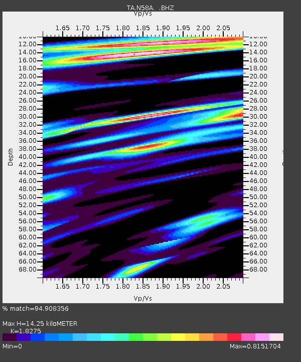
N58A Sunbury, PA, USA - Earthquake Result Viewer
| Earthquake location: |
Rat Islands, Aleutian Islands |
| Earthquake latitude/longitude: |
51.8/178.8 |
| Earthquake time(UTC): |
2014/06/23 (174) 20:53:09 GMT |
| Earthquake Depth: |
108 km |
| Earthquake Magnitude: |
7.9 MWW, 7.1 MI, 7.9 MWC |
| Earthquake Catalog/Contributor: |
NEIC PDE/NEIC COMCAT |
|
| Network: |
TA USArray Transportable Network (new EarthScope stations) |
| Station: |
N58A Sunbury, PA, USA |
| Lat/Lon: |
40.84 N/76.72 W |
| Elevation: |
200 m |
|
| Distance: |
66.9 deg |
| Az: |
52.989 deg |
| Baz: |
319.187 deg |
| Ray Param: |
0.057029676 |
| Estimated Moho Depth: |
14.25 km |
| Estimated Crust Vp/Vs: |
1.83 |
| Assumed Crust Vp: |
6.121 km/s |
| Estimated Crust Vs: |
3.349 km/s |
| Estimated Crust Poisson's Ratio: |
0.29 |
|
| Radial Match: |
94.908356 % |
| Radial Bump: |
397 |
| Transverse Match: |
78.308395 % |
| Transverse Bump: |
400 |
| SOD ConfigId: |
739768 |
| Insert Time: |
2014-07-07 21:54:46.196 +0000 |
| GWidth: |
2.5 |
| Max Bumps: |
400 |
| Tol: |
0.001 |
|

Signal To Noise
| Channel | StoN | STA | LTA |
| TA:N58A: :BHZ:20140623T21:03:19.849995Z | 3.6694965 | 8.45747E-6 | 2.3048042E-6 |
| TA:N58A: :BHN:20140623T21:03:19.849995Z | 1.5135204 | 2.6232528E-6 | 1.7332128E-6 |
| TA:N58A: :BHE:20140623T21:03:19.849995Z | 2.222444 | 4.636266E-6 | 2.0861114E-6 |
| Arrivals |
| Ps | 2.0 SECOND |
| PpPs | 6.4 SECOND |
| PsPs/PpSs | 8.4 SECOND |


