You are here: Home > Network List > US - United States National Seismic Network Stations List
> Station EGMT Eagleton, Montana, USA > Earthquake Result Viewer
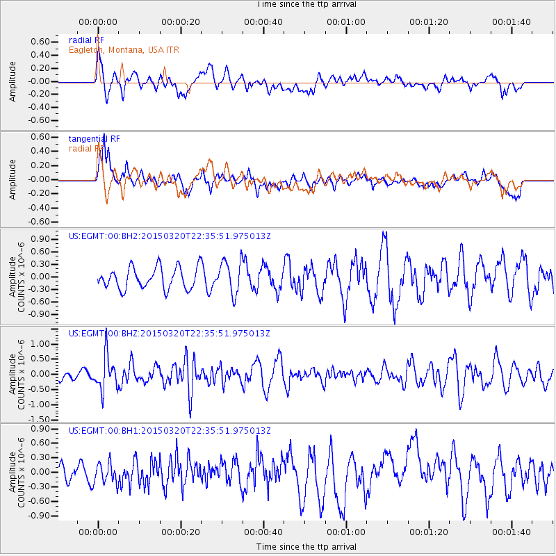
EGMT Eagleton, Montana, USA - Earthquake Result Viewer
*The percent match for this event was below the threshold and hence no stack was calculated.
| Earthquake location: |
Guerrero, Mexico |
| Earthquake latitude/longitude: |
18.0/-98.6 |
| Earthquake time(UTC): |
2015/03/20 (079) 22:30:07 GMT |
| Earthquake Depth: |
58 km |
| Earthquake Magnitude: |
5.4 MW, 5.3 mb, 4.6 MS |
| Earthquake Catalog/Contributor: |
ISC/ISC |
|
| Network: |
US United States National Seismic Network |
| Station: |
EGMT Eagleton, Montana, USA |
| Lat/Lon: |
48.02 N/109.75 W |
| Elevation: |
1055 m |
|
| Distance: |
31.3 deg |
| Az: |
345.483 deg |
| Baz: |
159.185 deg |
| Ray Param: |
$rayparam |
*The percent match for this event was below the threshold and hence was not used in the summary stack. |
|
| Radial Match: |
50.801655 % |
| Radial Bump: |
400 |
| Transverse Match: |
63.620117 % |
| Transverse Bump: |
400 |
| SOD ConfigId: |
7422571 |
| Insert Time: |
2019-04-17 20:35:25.104 +0000 |
| GWidth: |
2.5 |
| Max Bumps: |
400 |
| Tol: |
0.001 |
|
Signal To Noise
| Channel | StoN | STA | LTA |
| US:EGMT:00:BHZ:20150320T22:35:51.975013Z | 2.5734556 | 5.844626E-7 | 2.2711197E-7 |
| US:EGMT:00:BH1:20150320T22:35:51.975013Z | 0.5311539 | 2.0145067E-7 | 3.7926986E-7 |
| US:EGMT:00:BH2:20150320T22:35:51.975013Z | 1.621734 | 4.0966083E-7 | 2.5260667E-7 |
| Arrivals |
| Ps | |
| PpPs | |
| PsPs/PpSs | |


