You are here: Home > Network List > TA - USArray Transportable Network (new EarthScope stations) Stations List
> Station N61A South Mountain, Millburn, NJ, USA > Earthquake Result Viewer
N61A South Mountain, Millburn, NJ, USA - Earthquake Result Viewer
| Earthquake location: |
Rat Islands, Aleutian Islands |
| Earthquake latitude/longitude: |
51.8/178.8 |
| Earthquake time(UTC): |
2014/06/23 (174) 20:53:09 GMT |
| Earthquake Depth: |
108 km |
| Earthquake Magnitude: |
7.9 MWW, 7.1 MI, 7.9 MWC |
| Earthquake Catalog/Contributor: |
NEIC PDE/NEIC COMCAT |
|
| Network: |
TA USArray Transportable Network (new EarthScope stations) |
| Station: |
N61A South Mountain, Millburn, NJ, USA |
| Lat/Lon: |
40.75 N/74.30 W |
| Elevation: |
108 m |
|
| Distance: |
68.1 deg |
| Az: |
51.535 deg |
| Baz: |
320.205 deg |
| Ray Param: |
0.0562157 |
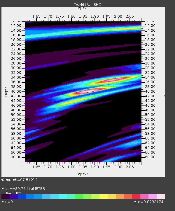
| Estimated Moho Depth: |
39.75 km |
| Estimated Crust Vp/Vs: |
1.87 |
| Assumed Crust Vp: |
6.283 km/s |
| Estimated Crust Vs: |
3.369 km/s |
| Estimated Crust Poisson's Ratio: |
0.30 |
|
| Radial Match: |
97.51212 % |
| Radial Bump: |
299 |
| Transverse Match: |
93.38935 % |
| Transverse Bump: |
400 |
| SOD ConfigId: |
739768 |
| Insert Time: |
2014-07-07 21:54:56.911 +0000 |
| GWidth: |
2.5 |
| Max Bumps: |
400 |
| Tol: |
0.001 |
|

Signal To Noise
| Channel | StoN | STA | LTA |
| TA:N61A: :BHZ:20140623T21:03:27.724995Z | 2.129006 | 6.1305745E-6 | 2.879548E-6 |
| TA:N61A: :BHN:20140623T21:03:27.724995Z | 1.9152967 | 2.6511311E-6 | 1.3841883E-6 |
| TA:N61A: :BHE:20140623T21:03:27.724995Z | 1.1985265 | 2.103397E-6 | 1.7549859E-6 |
| Arrivals |
| Ps | 5.7 SECOND |
| PpPs | 18 SECOND |
| PsPs/PpSs | 23 SECOND |


