You are here: Home > Network List > II - Global Seismograph Network (GSN - IRIS/IDA) Stations List
> Station WRAB Tennant Creek, NT, Australia > Earthquake Result Viewer
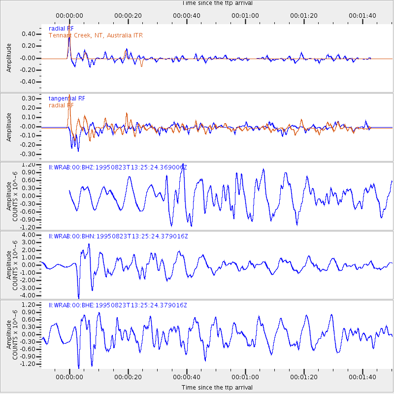
WRAB Tennant Creek, NT, Australia - Earthquake Result Viewer
*The percent match for this event was below the threshold and hence no stack was calculated.
| Earthquake location: |
Pacific-Antarctic Ridge |
| Earthquake latitude/longitude: |
-56.8/-141.7 |
| Earthquake time(UTC): |
1995/08/23 (235) 13:14:42 GMT |
| Earthquake Depth: |
10 km |
| Earthquake Magnitude: |
5.9 MB, 5.6 MS, 5.5 UNKNOWN, 6.2 MW |
| Earthquake Catalog/Contributor: |
WHDF/NEIC |
|
| Network: |
II Global Seismograph Network (GSN - IRIS/IDA) |
| Station: |
WRAB Tennant Creek, NT, Australia |
| Lat/Lon: |
19.93 S/134.36 E |
| Elevation: |
366 m |
|
| Distance: |
70.3 deg |
| Az: |
263.649 deg |
| Baz: |
144.415 deg |
| Ray Param: |
$rayparam |
*The percent match for this event was below the threshold and hence was not used in the summary stack. |
|
| Radial Match: |
66.3417 % |
| Radial Bump: |
353 |
| Transverse Match: |
73.7821 % |
| Transverse Bump: |
400 |
| SOD ConfigId: |
4480 |
| Insert Time: |
2010-03-01 23:25:29.928 +0000 |
| GWidth: |
2.5 |
| Max Bumps: |
400 |
| Tol: |
0.001 |
|
Signal To Noise
| Channel | StoN | STA | LTA |
| II:WRAB:00:BHN:19950823T13:25:24.379016Z | 3.8015234 | 1.5371206E-6 | 4.0434333E-7 |
| II:WRAB:00:BHE:19950823T13:25:24.379016Z | 1.4823612 | 5.342942E-7 | 3.6043457E-7 |
| II:WRAB:00:BHZ:19950823T13:25:24.369006Z | 1.2846916 | 4.402559E-7 | 3.4269382E-7 |
| Arrivals |
| Ps | |
| PpPs | |
| PsPs/PpSs | |


