You are here: Home > Network List > TA - USArray Transportable Network (new EarthScope stations) Stations List
> Station O55A Ligonier, PA, USA > Earthquake Result Viewer
O55A Ligonier, PA, USA - Earthquake Result Viewer
| Earthquake location: |
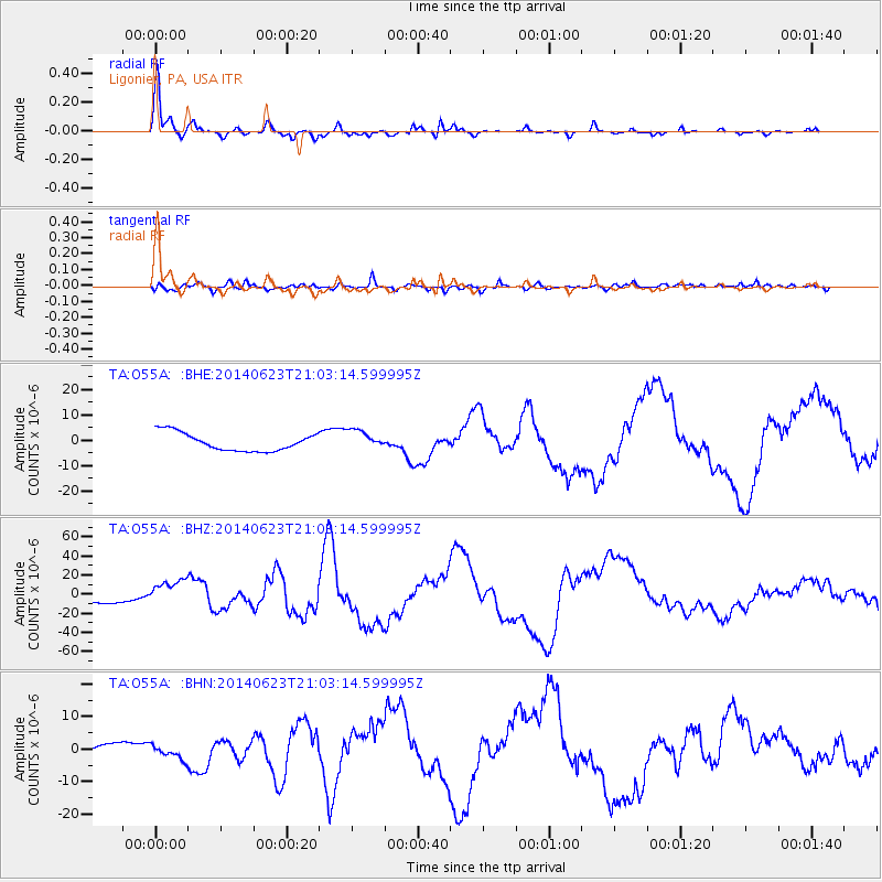
Rat Islands, Aleutian Islands |
| Earthquake latitude/longitude: |
51.8/178.8 |
| Earthquake time(UTC): |
2014/06/23 (174) 20:53:09 GMT |
| Earthquake Depth: |
108 km |
| Earthquake Magnitude: |
7.9 MWW, 7.1 MI, 7.9 MWC |
| Earthquake Catalog/Contributor: |
NEIC PDE/NEIC COMCAT |
|
| Network: |
TA USArray Transportable Network (new EarthScope stations) |
| Station: |
O55A Ligonier, PA, USA |
| Lat/Lon: |
40.21 N/79.30 W |
| Elevation: |
469 m |
|
| Distance: |
66.1 deg |
| Az: |
55.061 deg |
| Baz: |
318.338 deg |
| Ray Param: |
0.0575726 |
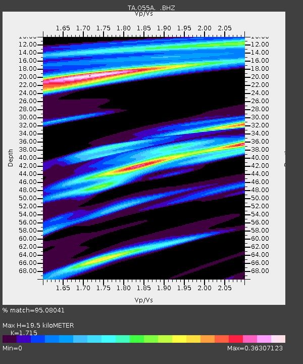
| Estimated Moho Depth: |
19.5 km |
| Estimated Crust Vp/Vs: |
1.72 |
| Assumed Crust Vp: |
6.121 km/s |
| Estimated Crust Vs: |
3.569 km/s |
| Estimated Crust Poisson's Ratio: |
0.24 |
|
| Radial Match: |
95.08041 % |
| Radial Bump: |
299 |
| Transverse Match: |
57.394897 % |
| Transverse Bump: |
400 |
| SOD ConfigId: |
739768 |
| Insert Time: |
2014-07-07 21:55:31.245 +0000 |
| GWidth: |
2.5 |
| Max Bumps: |
400 |
| Tol: |
0.001 |
|
Signal To Noise
| Channel | StoN | STA | LTA |
| TA:O55A: :BHZ:20140623T21:03:14.599995Z | 2.772246 | 1.3162131E-5 | 4.7478225E-6 |
| TA:O55A: :BHN:20140623T21:03:14.599995Z | 1.3975092 | 2.1662656E-6 | 1.5500905E-6 |
| TA:O55A: :BHE:20140623T21:03:14.599995Z | 1.1160731 | 3.9393776E-6 | 3.529677E-6 |
| Arrivals |
| Ps | 2.4 SECOND |
| PpPs | 8.3 SECOND |
| PsPs/PpSs | 11 SECOND |


