You are here: Home > Network List > II - Global Seismograph Network (GSN - IRIS/IDA) Stations List
> Station WRAB Tennant Creek, NT, Australia > Earthquake Result Viewer
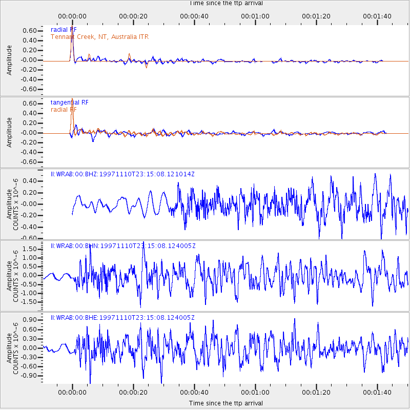
WRAB Tennant Creek, NT, Australia - Earthquake Result Viewer
*The percent match for this event was below the threshold and hence no stack was calculated.
| Earthquake location: |
Southeast Of Honshu, Japan |
| Earthquake latitude/longitude: |
31.2/140.5 |
| Earthquake time(UTC): |
1997/11/10 (314) 23:06:44 GMT |
| Earthquake Depth: |
86 km |
| Earthquake Magnitude: |
5.8 MB, 6.1 UNKNOWN, 6.1 MW |
| Earthquake Catalog/Contributor: |
WHDF/NEIC |
|
| Network: |
II Global Seismograph Network (GSN - IRIS/IDA) |
| Station: |
WRAB Tennant Creek, NT, Australia |
| Lat/Lon: |
19.93 S/134.36 E |
| Elevation: |
366 m |
|
| Distance: |
51.2 deg |
| Az: |
187.405 deg |
| Baz: |
6.742 deg |
| Ray Param: |
$rayparam |
*The percent match for this event was below the threshold and hence was not used in the summary stack. |
|
| Radial Match: |
78.05351 % |
| Radial Bump: |
343 |
| Transverse Match: |
71.906555 % |
| Transverse Bump: |
400 |
| SOD ConfigId: |
4480 |
| Insert Time: |
2010-03-01 23:25:31.030 +0000 |
| GWidth: |
2.5 |
| Max Bumps: |
400 |
| Tol: |
0.001 |
|
Signal To Noise
| Channel | StoN | STA | LTA |
| II:WRAB:00:BHN:19971110T23:15:08.124005Z | 3.9110987 | 4.7246172E-7 | 1.2080025E-7 |
| II:WRAB:00:BHE:19971110T23:15:08.124005Z | 3.1538336 | 2.8353915E-7 | 8.990302E-8 |
| II:WRAB:00:BHZ:19971110T23:15:08.121014Z | 1.6834148 | 1.4831348E-7 | 8.810275E-8 |
| Arrivals |
| Ps | |
| PpPs | |
| PsPs/PpSs | |


