You are here: Home > Network List > TA - USArray Transportable Network (new EarthScope stations) Stations List
> Station Q57A Strasburg, VA, USA > Earthquake Result Viewer
Q57A Strasburg, VA, USA - Earthquake Result Viewer
| Earthquake location: |
Rat Islands, Aleutian Islands |
| Earthquake latitude/longitude: |
51.8/178.8 |
| Earthquake time(UTC): |
2014/06/23 (174) 20:53:09 GMT |
| Earthquake Depth: |
108 km |
| Earthquake Magnitude: |
7.9 MWW, 7.1 MI, 7.9 MWC |
| Earthquake Catalog/Contributor: |
NEIC PDE/NEIC COMCAT |
|
| Network: |
TA USArray Transportable Network (new EarthScope stations) |
| Station: |
Q57A Strasburg, VA, USA |
| Lat/Lon: |
39.04 N/78.41 W |
| Elevation: |
324 m |
|
| Distance: |
67.4 deg |
| Az: |
55.338 deg |
| Baz: |
319.015 deg |
| Ray Param: |
0.056699988 |
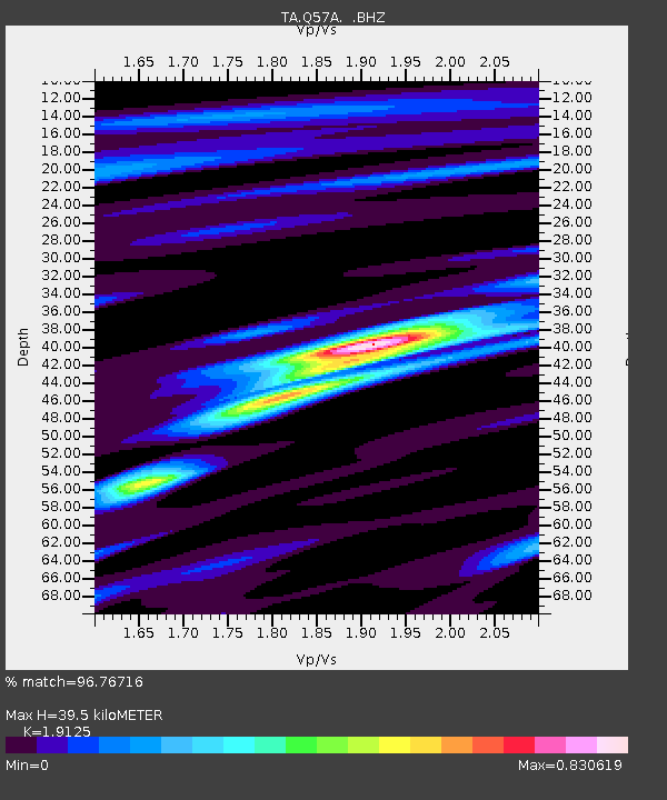
| Estimated Moho Depth: |
39.5 km |
| Estimated Crust Vp/Vs: |
1.91 |
| Assumed Crust Vp: |
6.159 km/s |
| Estimated Crust Vs: |
3.22 km/s |
| Estimated Crust Poisson's Ratio: |
0.31 |
|
| Radial Match: |
96.76716 % |
| Radial Bump: |
302 |
| Transverse Match: |
67.51294 % |
| Transverse Bump: |
400 |
| SOD ConfigId: |
739768 |
| Insert Time: |
2014-07-07 21:56:49.363 +0000 |
| GWidth: |
2.5 |
| Max Bumps: |
400 |
| Tol: |
0.001 |
|

Signal To Noise
| Channel | StoN | STA | LTA |
| TA:Q57A: :BHZ:20140623T21:03:23.074971Z | 1.9211648 | 7.860864E-6 | 4.0917175E-6 |
| TA:Q57A: :BHN:20140623T21:03:23.074971Z | 0.606943 | 1.1560729E-6 | 1.904747E-6 |
| TA:Q57A: :BHE:20140623T21:03:23.074971Z | 0.8305635 | 2.4735937E-6 | 2.9782113E-6 |
| Arrivals |
| Ps | 6.1 SECOND |
| PpPs | 18 SECOND |
| PsPs/PpSs | 24 SECOND |


