You are here: Home > Network List > TA - USArray Transportable Network (new EarthScope stations) Stations List
> Station Q60A Greensboro, MD, USA > Earthquake Result Viewer
Q60A Greensboro, MD, USA - Earthquake Result Viewer
| Earthquake location: |
Rat Islands, Aleutian Islands |
| Earthquake latitude/longitude: |
51.8/178.8 |
| Earthquake time(UTC): |
2014/06/23 (174) 20:53:09 GMT |
| Earthquake Depth: |
108 km |
| Earthquake Magnitude: |
7.9 MWW, 7.1 MI, 7.9 MWC |
| Earthquake Catalog/Contributor: |
NEIC PDE/NEIC COMCAT |
|
| Network: |
TA USArray Transportable Network (new EarthScope stations) |
| Station: |
Q60A Greensboro, MD, USA |
| Lat/Lon: |
39.00 N/75.84 W |
| Elevation: |
14 m |
|
| Distance: |
68.7 deg |
| Az: |
53.722 deg |
| Baz: |
320.022 deg |
| Ray Param: |
0.05583956 |
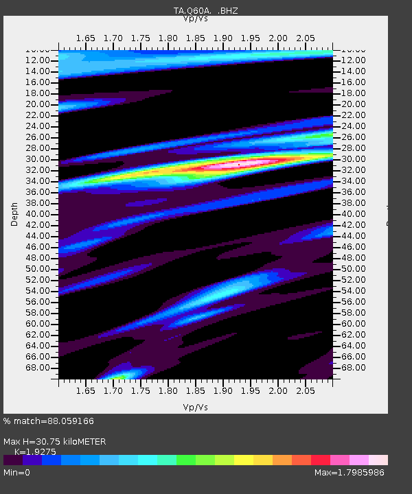
| Estimated Moho Depth: |
30.75 km |
| Estimated Crust Vp/Vs: |
1.93 |
| Assumed Crust Vp: |
6.287 km/s |
| Estimated Crust Vs: |
3.262 km/s |
| Estimated Crust Poisson's Ratio: |
0.32 |
|
| Radial Match: |
88.059166 % |
| Radial Bump: |
400 |
| Transverse Match: |
77.38612 % |
| Transverse Bump: |
400 |
| SOD ConfigId: |
739768 |
| Insert Time: |
2014-07-07 21:56:57.885 +0000 |
| GWidth: |
2.5 |
| Max Bumps: |
400 |
| Tol: |
0.001 |
|
Signal To Noise
| Channel | StoN | STA | LTA |
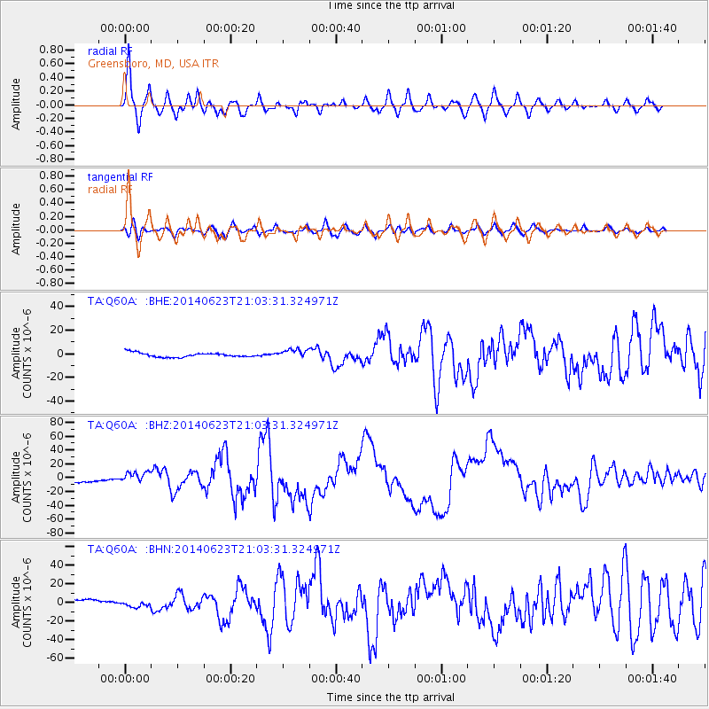
| TA:Q60A: :BHZ:20140623T21:03:31.324971Z | 2.5689535 | 7.816597E-6 | 3.0427163E-6 |
| TA:Q60A: :BHN:20140623T21:03:31.324971Z | 1.3861451 | 3.3133742E-6 | 2.3903517E-6 |
| TA:Q60A: :BHE:20140623T21:03:31.324971Z | 2.1230192 | 3.843873E-6 | 1.8105691E-6 |
| Arrivals |
| Ps | 4.7 SECOND |
| PpPs | 14 SECOND |
| PsPs/PpSs | 19 SECOND |


